File:Furth bei Göttweig - ND Hohlweg Zellergraben - 2 - Tafel Donauterrasse und Lössprofil des Themenwegs.jpg
Original file (3,333 × 5,000 pixels, file size: 6.4 MB, MIME type: image/jpeg)
Captions
Summary
editDescriptionFurth bei Göttweig - ND Hohlweg Zellergraben - 2 - Tafel Donauterrasse und Lössprofil des Themenwegs.jpg |
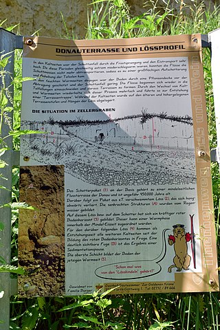
Deutsch: Der Hohlweg Zellergraben in Furth bei Göttweig ist wegen seiner Lösswände - und weil viele Gräben in der Vergangenheit zugeschüttet wurden - ein Naturdenkmal. Abgebildet ist eine Tafel des Themenwegs Löss und Wein, auf der das Profil der Lösswände erklärt wird.
|
Date | |
Source | Own work |
Author | Haeferl |
Camera location | 48° 22′ 30.77″ N, 15° 36′ 16.8″ E | View this and other nearby images on: OpenStreetMap | 48.375213; 15.604666 |
---|
Licensing
edit- You are free:
- to share – to copy, distribute and transmit the work
- to remix – to adapt the work
- Under the following conditions:
- attribution – You must give appropriate credit, provide a link to the license, and indicate if changes were made. You may do so in any reasonable manner, but not in any way that suggests the licensor endorses you or your use.
- share alike – If you remix, transform, or build upon the material, you must distribute your contributions under the same or compatible license as the original.
This image was uploaded as part of Wiki Loves Earth 2022.
aragonés ∙ asturianu ∙ azərbaycanca ∙ Bahasa Indonesia ∙ Bahasa Melayu ∙ brezhoneg ∙ català ∙ čeština ∙ Cymraeg ∙ dagbanli ∙ Deutsch ∙ eesti ∙ English ∙ español ∙ euskara ∙ français ∙ galego ∙ hrvatski ∙ italiano ∙ latviešu ∙ Nederlands ∙ norsk ∙ norsk bokmål ∙ português ∙ polski ∙ português do Brasil ∙ română ∙ shqip ∙ sicilianu ∙ slovenščina ∙ svenska ∙ Tagalog ∙ Türkçe ∙ Ελληνικά ∙ беларуская (тарашкевіца) ∙ български ∙ македонски ∙ русский ∙ српски / srpski ∙ українська ∙ ქართული ∙ հայերեն ∙ नेपाली ∙ मराठी ∙ বাংলা ∙ മലയാളം ∙ ไทย ∙ 한국어 ∙ 日本語 ∙ 中文 ∙ 中文(台灣) ∙ 中文(简体) ∙ 中文(繁體) ∙ עברית ∙ اردو ∙ العربية ∙ فارسی ∙ +/− |
Diese Datei wurde im Rahmen von WikiDaheim 2022 in Österreich erstellt und hochgeladen. Sie wurde dem Themenbereich Naturschutz zugeordnet. |
File history
Click on a date/time to view the file as it appeared at that time.
Date/Time | Thumbnail | Dimensions | User | Comment | |
---|---|---|---|---|---|
current | 22:48, 16 July 2022 | 3,333 × 5,000 (6.4 MB) | Haeferl (talk | contribs) | Uploaded own work with UploadWizard |
You cannot overwrite this file.
File usage on Commons
There are no pages that use this file.
Metadata
This file contains additional information such as Exif metadata which may have been added by the digital camera, scanner, or software program used to create or digitize it. If the file has been modified from its original state, some details such as the timestamp may not fully reflect those of the original file. The timestamp is only as accurate as the clock in the camera, and it may be completely wrong.
Camera manufacturer | NIKON CORPORATION |
---|---|
Camera model | NIKON D5300 |
Author | Haeferl |
Copyright holder |
|
Exposure time | 1/80 sec (0.0125) |
F-number | f/10 |
ISO speed rating | 100 |
Date and time of data generation | 16:27, 11 June 2022 |
Lens focal length | 38 mm |
Latitude | 48° 22′ 30.77″ N |
Longitude | 15° 36′ 16.8″ E |
Altitude | 239 meters above sea level |
City shown | Furth bei Göttweig |
Orientation | Normal |
Horizontal resolution | 300 dpi |
Vertical resolution | 300 dpi |
Software used | Adobe Photoshop Elements 8.0 Windows |
File change date and time | 16:13, 15 July 2022 |
Y and C positioning | Centered |
Exposure Program | Aperture priority |
Exif version | 2.3 |
Date and time of digitizing | 16:27, 11 June 2022 |
Meaning of each component |
|
Image compression mode | 4 |
APEX exposure bias | −0.33333333333333 |
Maximum land aperture | 4.5 APEX (f/4.76) |
Metering mode | Center weighted average |
Light source | Unknown |
Flash | Flash did not fire |
DateTime subseconds | 90 |
DateTimeOriginal subseconds | 90 |
DateTimeDigitized subseconds | 90 |
Supported Flashpix version | 1 |
Color space | sRGB |
Sensing method | One-chip color area sensor |
File source | Digital still camera |
Scene type | A directly photographed image |
Custom image processing | Normal process |
Exposure mode | Auto exposure |
White balance | Auto white balance |
Digital zoom ratio | 1 |
Focal length in 35 mm film | 57 mm |
Scene capture type | Standard |
Scene control | None |
Contrast | Normal |
Saturation | Normal |
Sharpness | Normal |
Subject distance range | Unknown |
GPS time (atomic clock) | 14:27 |
Reference for direction of image | True direction |
Direction of image | 0 |
Geodetic survey data used | WGS-84 |
Latitude destination | 48° 22′ 31.11″ N |
Longitude of destination | 15° 36′ 16.8″ E |
GPS date | 11 June 2022 |
GPS tag version | 0.0.2.2 |
IIM version | 17,900 |
Keywords |
|
Sublocation of city shown | Furth bei Göttweig |
Province or state shown | Niederösterreich |
Code for country shown | AUT |
Country shown | Österreich |
Supported Flashpix version | 1 |
Image width | 3,333 px |
Image height | 5,000 px |
Contact information | Haeferl@chello.at
http://commons.wikimedia.org/wiki/User:Haeferl
|
Date metadata was last modified | 18:13, 15 July 2022 |
Unique ID of original document | xmp.did:4E4CF6494804ED1192EDAF982C8A83A2 |