File:Future Tesco's, Orpington - geograph.org.uk - 720189.jpg
Future_Tesco's,_Orpington_-_geograph.org.uk_-_720189.jpg (640 × 480 pixels, file size: 124 KB, MIME type: image/jpeg)
Captions
Captions
Summary
edit
| Description |
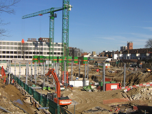
English: Future Tesco's, Orpington. This site used to be a multistorey carpark. It is being replaced by yet another Tesco's, with some residential development and public parking thrown in to satisfy the planners.
As with most such developments, there have been mixed feelings about it. On the one hand, it is claimed that being a town centre site (the buildings on the right are the back of the High Street) it will attract more people to the area; the counterclaim is that people will use the new store for all their needs, leading to the death of the rest of the town. To some extent, the town centre is already under pressure, with Marks and Spencer and Currys both having moved out to replacement sites on the bypass a couple of miles away (easy for those with cars but less convenient for the large number of people who come to Orpington by bus, or who work in the town centre). (See 720213 for the new Marks and Spencer). At least Sainsbury's is keeping faith in the town centre, by moving from its current rather cramped site into the larger site vacated by Marks and Spencer. The other concern is traffic - Station Road is already very congested, particularly in rush hour, and the extra traffic that a large Tesco's will inevitably attract will only make matters worse. In the meantime, the loss of a large amount of parking, even if it will be partially replaced when the development is complete, has had a detrimental impact on the occupancy of the large office block behind, with significant areas available to let. |
| Date | |
| Source | From geograph.org.uk |
| Author | Ian Capper |
| Attribution (required by the license) | Ian Capper / Future Tesco's, Orpington / |
| Camera location | | View this and other nearby images on: OpenStreetMap |
|---|
_heading:22.00&language=en)
| Object location | | View this and other nearby images on: OpenStreetMap |
|---|
_heading:22.00&language=en)
Licensing
edit

|
This image was taken from the Geograph project collection. See this photograph's page on the Geograph website for the photographer's contact details. The copyright on this image is owned by Ian Capper and is licensed for reuse under the Creative Commons Attribution-ShareAlike 2.0 license.
|
- You are free:
- to share – to copy, distribute and transmit the work
- to remix – to adapt the work
- Under the following conditions:
- attribution – You must give appropriate credit, provide a link to the license, and indicate if changes were made. You may do so in any reasonable manner, but not in any way that suggests the licensor endorses you or your use.
- share alike – If you remix, transform, or build upon the material, you must distribute your contributions under the same or compatible license as the original.
File history
Click on a date/time to view the file as it appeared at that time.
| Date/Time | Thumbnail | Dimensions | User | Comment | |
|---|---|---|---|---|---|
| current | 04:43, 19 February 2011 | | 640 × 480 (124 KB) | GeographBot (talk | contribs) | == {{int:filedesc}} == {{Information |description={{en|1=Future Tesco's, Orpington This site used to be a multistorey carpark. It is being replaced by yet another Tesco's, with some residential development and public parking thrown in to satisfy the plan |
You cannot overwrite this file.
File usage on Commons
There are no pages that use this file.