File:GENERAL VIEW OF TOWPATH THROUGH HOLLOW NORTH OF TUNNEL, NOTE TOW ROPE CHAFING ON ROCK SLOPE - Chesapeake and Ohio Canal, Paw-Paw Tunnel, 155.2 - 155.8 miles above tidewater, HABS MD,1-OLDTO.V,4-2.tif

Size of this JPG preview of this TIF file: 428 × 600 pixels. Other resolutions: 171 × 240 pixels | 342 × 480 pixels | 548 × 768 pixels | 730 × 1,024 pixels | 1,461 × 2,048 pixels | 3,567 × 5,000 pixels.
Original file (3,567 × 5,000 pixels, file size: 17.01 MB, MIME type: image/tiff)
Captions
Captions
Add a one-line explanation of what this file represents
Summary edit
| GENERAL VIEW OF TOWPATH THROUGH HOLLOW NORTH OF TUNNEL, NOTE TOW ROPE CHAFING ON ROCK SLOPE - Chesapeake and Ohio Canal, Paw-Paw Tunnel, 155.2 - 155.8 miles above tidewater, Oldtown, Allegany County, MD | ||||
|---|---|---|---|---|
| Title |
GENERAL VIEW OF TOWPATH THROUGH HOLLOW NORTH OF TUNNEL, NOTE TOW ROPE CHAFING ON ROCK SLOPE - Chesapeake and Ohio Canal, Paw-Paw Tunnel, 155.2 - 155.8 miles above tidewater, Oldtown, Allegany County, MD |
|||
| Description |
Boucher, Jack E, photographer |
|||
| Depicted place | Maryland; Allegany County; Oldtown | |||
| Date | Documentation compiled after 1933 | |||
| Dimensions | 5 x 7 in. | |||
| Current location |
Library of Congress Prints and Photographs Division Washington, D.C. 20540 USA http://hdl.loc.gov/loc.pnp/pp.print |
|||
| Accession number |
HABS MD,1-OLDTO.V,4-2 |
|||
| Credit line |
|
|||
| Notes |
|
|||
| Source | https://www.loc.gov/pictures/item/md0889.photos.081530p | |||
| Permission (Reusing this file) |
|
|||

| Object location | | View this and other nearby images on: OpenStreetMap |
|---|
File history
Click on a date/time to view the file as it appeared at that time.
| Date/Time | Thumbnail | Dimensions | User | Comment | |
|---|---|---|---|---|---|
| current | 12:25, 22 July 2014 | 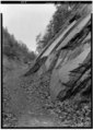 | 3,567 × 5,000 (17.01 MB) | Fæ (talk | contribs) | GWToolset: Creating mediafile for Fæ. HABS 21 July 2014 (1601:1800) |
You cannot overwrite this file.
File usage on Commons
The following page uses this file: