File:GON Airport Diagram.svg

Size of this PNG preview of this SVG file: 378 × 548 pixels. Other resolutions: 165 × 240 pixels | 331 × 480 pixels | 530 × 768 pixels | 706 × 1,024 pixels | 1,413 × 2,048 pixels.
Original file (SVG file, nominally 378 × 548 pixels, file size: 516 KB)
Captions
Captions
Add a one-line explanation of what this file represents
| Description |
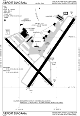
English: FAA Airport Diagram of Groton-New London Airport in Groton, CT. W3C-validity not checked. |
|||
| Date | ||||
| Source | FAA Airport Diagrams Taken from PDF on FAA site and converted to SVG using this method. | |||
| Author | United States Federal Aviation Administration | |||
| Permission (Reusing this file) |
|

| Object location | | View this and other nearby images on: OpenStreetMap |
|---|
File history
Click on a date/time to view the file as it appeared at that time.
| Date/Time | Thumbnail | Dimensions | User | Comment | |
|---|---|---|---|---|---|
| current | 15:04, 15 July 2011 | | 378 × 548 (516 KB) | Grendelkhan (talk | contribs) | {{Information |Description ={{en|1=FAA Airport Diagram of Groton-New London Airport in Groton, CT.}} |Source =[http://www.faa.gov/airports/runway_safety/diagrams/ FAA Aiport Diagrams] Taken from PDF on FAA site and converted to SVG using [[:en: |
You cannot overwrite this file.
File usage on Commons
The following page uses this file:
File usage on other wikis
The following other wikis use this file:
- Usage on en.wikipedia.org
- Usage on ur.wikipedia.org
- Usage on www.wikidata.org