File:GO Train System Map.png
Size of this preview: 697 × 599 pixels. Other resolutions: 279 × 240 pixels | 558 × 480 pixels | 841 × 723 pixels.
Original file (841 × 723 pixels, file size: 69 KB, MIME type: image/png)
Captions
Captions
Add a one-line explanation of what this file represents

|
File:GO System Map.svg is a vector version of this file. It should be used in place of this PNG file when not inferior.
File:GO Train System Map.png → File:GO System Map.svg
For more information, see Help:SVG. |
 |
Summary
edit
| Description |
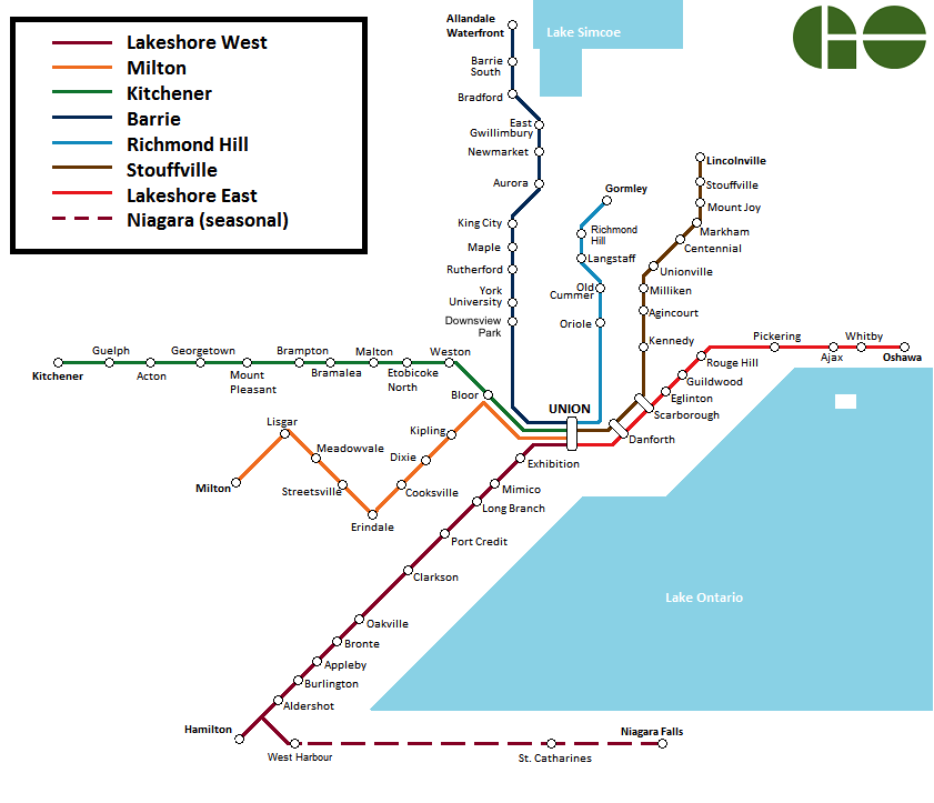
English: A diagram of the GO Train system. Created with Microsoft Paint. |
| Date | |
| Source | Own work; also utilized File:GO Transit logo.svg |
| Author | Natural RX; Mechamind90 |
Licensing
edit
I, the copyright holder of this work, hereby publish it under the following license:
| This file is made available under the Creative Commons CC0 1.0 Universal Public Domain Dedication. | |
| The person who associated a work with this deed has dedicated the work to the public domain by waiving all of their rights to the work worldwide under copyright law, including all related and neighboring rights, to the extent allowed by law. You can copy, modify, distribute and perform the work, even for commercial purposes, all without asking permission.
|
File history
Click on a date/time to view the file as it appeared at that time.
| Date/Time | Thumbnail | Dimensions | User | Comment | |
|---|---|---|---|---|---|
| current | 00:11, 10 January 2018 | | 841 × 723 (69 KB) | Blaixx (talk | contribs) | + Downsview Park |
| 21:12, 27 November 2017 |  | 841 × 723 (68 KB) | Blaixx (talk | contribs) | Stouffville line makes stops at Danforth and Scarborough | |
| 16:03, 25 November 2016 |  | 841 × 723 (46 KB) | Natural RX (talk | contribs) | + Gormley | |
| 19:37, 8 June 2015 |  | 841 × 723 (60 KB) | Natural RX (talk | contribs) | + West Harbour | |
| 16:07, 6 October 2014 |  | 841 × 723 (59 KB) | Natural RX (talk | contribs) | update colours and logo | |
| 06:22, 15 February 2013 |  | 841 × 723 (57 KB) | Natural RX (talk | contribs) | Updated outdated version. | |
| 09:37, 12 February 2013 |  | 841 × 678 (55 KB) | Natural RX (talk | contribs) | + Acton | |
| 16:33, 27 January 2012 |  | 841 × 723 (57 KB) | Natural RX (talk | contribs) | + Allandale Waterfront | |
| 23:42, 1 January 2012 |  | 841 × 678 (55 KB) | Natural RX (talk | contribs) | + Niagara in legend | |
| 05:03, 20 December 2011 |  | 841 × 678 (54 KB) | Natural RX (talk | contribs) |
You cannot overwrite this file.
File usage on Commons
The following 15 pages use this file:
- User:*Youngjin/GTA transit/2015 June 1-10
- User:*Youngjin/GTA transit/2016 November 21-30
- User:*Youngjin/GTA transit/2017 November 21-30
- User:*Youngjin/GTA transit/2018 January
- User:Chumwa/OgreBot/Potential transport maps/2016 November 21-30
- User:Chumwa/OgreBot/Potential transport maps/2017 November 21-30
- User:Chumwa/OgreBot/Public transport information/2015 June 1-10
- User:Chumwa/OgreBot/Public transport information/2016 November 21-30
- User:Chumwa/OgreBot/Public transport information/2017 November 21-30
- User:Chumwa/OgreBot/Transport Maps/2015 June 1-10
- User:Chumwa/OgreBot/Transport Maps/2016 November 21-30
- User:Chumwa/OgreBot/Transport Maps/2017 November 21-30
- User:Chumwa/OgreBot/Travel and communication maps/2016 November 21-30
- User:Chumwa/OgreBot/Travel and communication maps/2017 November 21-30
- Category:GO Transit
File usage on other wikis
The following other wikis use this file:
- Usage on de.wikipedia.org
- Usage on fi.wikipedia.org
- Usage on simple.wikipedia.org
- Usage on www.wikidata.org