File:Gaemi Oct 5 2012 0550Z (gallery).jpg

Size of this preview: 768 × 600 pixels. Other resolutions: 307 × 240 pixels | 615 × 480 pixels | 983 × 768 pixels | 1,280 × 1,000 pixels | 2,560 × 2,000 pixels | 6,400 × 5,000 pixels.
Original file (6,400 × 5,000 pixels, file size: 4.44 MB, MIME type: image/jpeg)
Captions
Captions
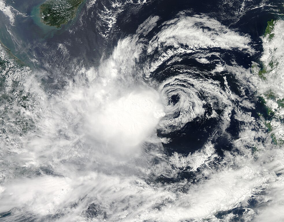
Tropical Storm Gaemi (21W) approaching Vietnam
Summary
edit.jpg&action=edit§ion=1)
| Description |
English: Gaemi formed as a tropical depression over the western Pacific Ocean on October 1, 2012, according to Unisys Weather. It soon strengthened to a tropical storm and lingered off the Philippines, dropping heavy rain on the northern and western parts of the archipelago, AccuWeather reported. By October 5, Gaemi appeared headed for the coast of Vietnam.
The Moderate Resolution Imaging Spectroradiometer (MODIS) on NASA’s Aqua satellite captured this natural-color image of Gaemi on October 5, 2012. The storm lacked a distinct eye and instead appeared as a mass of clouds over the South China Sea. On October 5, the U.S. Navy’s Joint Typhoon Warning Center (JTWC) reported that Gaemi was located about 425 nautical miles (785 kilometers) east-southeast of Huê, Vietnam. The storm had maximum sustained winds of 35 knots (65 kilometers per hour) and gusts up to 45 knots (85 kilometers per hour). The JTWC storm track showed Gaemi moving west toward Vietnam. AccuWeather reported that, although Gaemi did not have intense winds, the storm held the potential to bring heavy rains and floods to parts of Vietnam, Laos, Cambodia, and Thailand in the coming days. |
| Date | |
| Source | https://lance.modaps.eosdis.nasa.gov/cgi-bin/imagery/single.cgi?image=Gaemi.A2012279.0550.1km.jpg |
| Author | National Aeronautics and Space Administration, LANCE/EOSDIS Rapid Response, captured on Aqua satellite |
| Metadata | https://lance.modaps.eosdis.nasa.gov/cgi-bin/imagery/single.cgi?metadata=Gaemi.A2012279.0550.txt |
| Satellite | Aqua |
| Camera location | | View this and other nearby images on: OpenStreetMap |
|---|
.jpg¶ms=014.000000_N_0114.000000_E_globe:Earth_type:camera__&language=en)
Licensing
edit.jpg&action=edit§ion=2)
| This file is in the public domain in the United States because it was solely created by NASA. NASA copyright policy states that "NASA material is not protected by copyright unless noted". (See Template:PD-USGov, NASA copyright policy page or JPL Image Use Policy.) | ||
 |
Warnings:
|
File history
Click on a date/time to view the file as it appeared at that time.
| Date/Time | Thumbnail | Dimensions | User | Comment | |
|---|---|---|---|---|---|
| current | 14:33, 23 August 2023 | | 6,400 × 5,000 (4.44 MB) | Nino Marakot (talk | contribs) | Uploaded a work by National Aeronautics and Space Administration, LANCE/EOSDIS Rapid Response, captured on Aqua satellite from https://lance.modaps.eosdis.nasa.gov/cgi-bin/imagery/single.cgi?image=Gaemi.A2012279.0550.1km.jpg with UploadWizard |
You cannot overwrite this file.
File usage on Commons
There are no pages that use this file.
.jpg&oldid=795582740)