File:Gamor-suedwestansicht.jpg

Size of this preview: 800 × 378 pixels. Other resolutions: 320 × 151 pixels | 640 × 302 pixels | 1,024 × 483 pixels | 1,803 × 851 pixels.
Original file (1,803 × 851 pixels, file size: 480 KB, MIME type: image/jpeg)
Captions
Captions
Add a one-line explanation of what this file represents
Summary
edit
| Description |
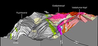
Deutsch: Blick ins Hintergamor und Val di Gastei (Ötztaler Alpen) aus der Gegend der Norberthöhe. Relief auf Basis eines einfachen Geländemodells mit gerenderter geologischer Karte. Darstellung des Südostrandes des Engadiner Fensters am Treffpunkt von Engadiner Linie und Schlinig-Überschiebung. |
| Date | |
| Source | Own work |
| Author | Claus Roderich Mattmüller |
Grau = Bündnerschiefer, Grün = Metabasalt, Rot = Orthogneis, Rosa = Paragneis, Hellblau = Dolomit, Blassgelb = Schutt, Moräne
Licensing
edit
I, the copyright holder of this work, hereby publish it under the following licenses:

|
Permission is granted to copy, distribute and/or modify this document under the terms of the GNU Free Documentation License, Version 1.2 or any later version published by the Free Software Foundation; with no Invariant Sections, no Front-Cover Texts, and no Back-Cover Texts. A copy of the license is included in the section entitled GNU Free Documentation License. |
This file is licensed under the Creative Commons Attribution 3.0 Unported license.
- You are free:
- to share – to copy, distribute and transmit the work
- to remix – to adapt the work
- Under the following conditions:
- attribution – You must give appropriate credit, provide a link to the license, and indicate if changes were made. You may do so in any reasonable manner, but not in any way that suggests the licensor endorses you or your use.
You may select the license of your choice.
File history
Click on a date/time to view the file as it appeared at that time.
| Date/Time | Thumbnail | Dimensions | User | Comment | |
|---|---|---|---|---|---|
| current | 17:37, 30 August 2014 | | 1,803 × 851 (480 KB) | Claus Roderich Mattmüller (talk | contribs) | {{Information |Description ={{de|1=Blick ins Hintergamor und Val di Gastei (Ötztaler Alpen) aus der Gegend der Norberthöhe. Relief auf Basis eines einfachen Geländemodells mit gerenderter geologischer Karte. Darstellung des Südostrandes des Enga... |
You cannot overwrite this file.
File usage on Commons
There are no pages that use this file.
File usage on other wikis
The following other wikis use this file:
- Usage on de.wikipedia.org