File:Gare de moret v3.jpg
Size of this preview: 789 × 600 pixels. Other resolutions: 316 × 240 pixels | 632 × 480 pixels | 830 × 631 pixels.
Original file (830 × 631 pixels, file size: 34 KB, MIME type: image/jpeg)
Captions
Captions
Add a one-line explanation of what this file represents
Summary
edit
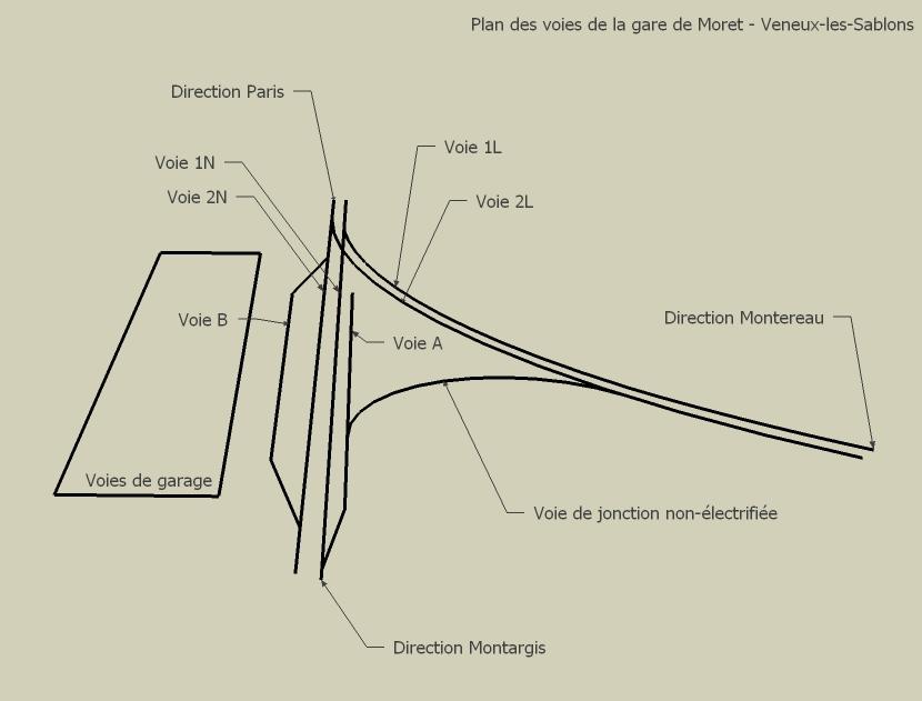
| Description | Version 2 du plan des voies de la gare de Moret - Veneux-les-Sablons |
| Date | 06/05/08 |
| Source | Own work |
| Author | Tibidibtibo |
| Camera location | | View this and other nearby images on: OpenStreetMap |
|---|

|
File:GareMoretVeneux plan des voies.svg is a vector version of this file. It should be used in place of this JPG file when not inferior.
File:Gare de moret v3.jpg → File:GareMoretVeneux plan des voies.svg
For more information, see Help:SVG. |
 |
Licensing
edit
| I, the copyright holder of this work, release this work into the public domain. This applies worldwide. In some countries this may not be legally possible; if so: I grant anyone the right to use this work for any purpose, without any conditions, unless such conditions are required by law. |
File history
Click on a date/time to view the file as it appeared at that time.
| Date/Time | Thumbnail | Dimensions | User | Comment | |
|---|---|---|---|---|---|
| current | 19:05, 6 May 2008 | | 830 × 631 (34 KB) | Tibidibtibo (talk | contribs) | {{Information |Description=Version 2 du plan des voies de la gare de Moret - Veneux-les-Sablons |Source=travail personnel |Date=06/05/08 |Author= Tibidibtibo |Permission= |other_versions= }} |
You cannot overwrite this file.
File usage on Commons
There are no pages that use this file.