File:Gascoyne, chart of Cephalonia.jpg

Size of this preview: 357 × 599 pixels. Other resolutions: 143 × 240 pixels | 286 × 480 pixels | 703 × 1,179 pixels.
Original file (703 × 1,179 pixels, file size: 460 KB, MIME type: image/jpeg)
Captions
Captions
Add a one-line explanation of what this file represents
Summary
edit
| Description |
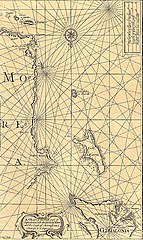
English: Joel Gascoyne, “A chart of the south part of Cephalonia, with the Islands of Zante, and the coast of Morea from C. Chiarese, to C. Sapienza". (Print of two contiguous charts: this is a left-hand crop.) |
| Date | |
| Source | David Rumsey Map Collection |
| Author | Joel Gasoyne |
Licensing
edit
|
This work is in the public domain in its country of origin and other countries and areas where the copyright term is the author's life plus 70 years or fewer. This work is in the public domain in the United States because it was published (or registered with the U.S. Copyright Office) before January 1, 1929. | |
| This file has been identified as being free of known restrictions under copyright law, including all related and neighboring rights. | |
File history
Click on a date/time to view the file as it appeared at that time.
| Date/Time | Thumbnail | Dimensions | User | Comment | |
|---|---|---|---|---|---|
| current | 10:12, 8 October 2020 | | 703 × 1,179 (460 KB) | Ttocserp (talk | contribs) | Uploaded a work by Joel Gasoyne from David Rumsey Map Collection with UploadWizard |
You cannot overwrite this file.
File usage on Commons
There are no pages that use this file.
File usage on other wikis
The following other wikis use this file:
- Usage on en.wikipedia.org