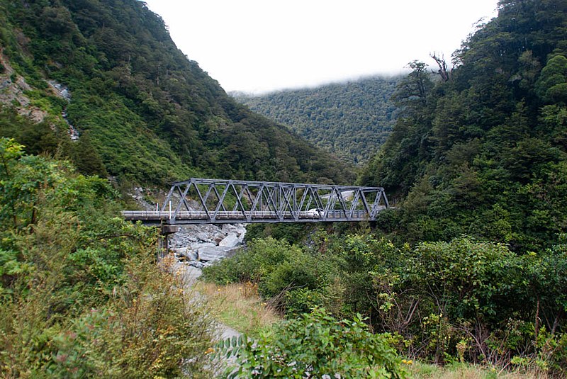
File:Gates of Haast bridge 02.jpg

Original file (1,000 × 669 pixels, file size: 216 KB, MIME type: image/jpeg)
Captions
Captions
Summary edit
| DescriptionGates of Haast bridge 02.jpg |
English: Going through the Haast Pass March 11, 2014 West Coast, South Island, New Zealand.
Haast Pass is a mountain pass in the Southern Alps of the South Island of New Zealand. It is named for Julius von Haast, a 19th-century explorer who was also geologist for the Provincial government of Canterbury. The pass was used by Māori in pre-European times, but not on a regular basis. It is one of the three passes where a road crosses over the Southern Alps, the other two being Lewis Pass and Arthur's Pass, although the Homer Tunnel also passes under the Main Divide. The road through Haast Pass (State Highway 6) was converted from a rough track to a formed road in 1966 and finally received a complete tarmac surface by 1995. In the early 20th century, a railway from the West Coast through the pass to Otago was considered; it would have linked the Ross Branch with the Otago Central Railway, which then terminated in Omakau. However, the line never came to fruition; the Otago Central Railway terminated in Cromwell and no railway was built south of Ross, just a lightly laid bush tramway to serve logging interests near Lake Ianthe. Fantail falls, in the Haast pass. The Haast Pass rises to a height of 562 metres above sea level at the saddle between the valleys of the Haast and Makarora Rivers. As such, it is the lowest of the passes traversing the Southern Alps. The Haast Pass road is devoid of any settlements between Haast and Makarora. The road passes through predominantly unmodified beech forest. The pass itself is within the limits of Mount Aspiring National Park and forms part of the boundary between Otago and the West Coast. For more Info: en.wikipedia.org/wiki/Haast_Pass |
| Date | |
| Source | https://www.flickr.com/photos/joceykinghorn/13453728575/ |
| Author | Jocelyn Kinghorn |
| Camera location | 44° 06′ 13.53″ S, 169° 20′ 54.53″ E | View this and other nearby images on: OpenStreetMap |
|---|
Licensing edit
- You are free:
- to share – to copy, distribute and transmit the work
- to remix – to adapt the work
- Under the following conditions:
- attribution – You must give appropriate credit, provide a link to the license, and indicate if changes were made. You may do so in any reasonable manner, but not in any way that suggests the licensor endorses you or your use.
- share alike – If you remix, transform, or build upon the material, you must distribute your contributions under the same or compatible license as the original.
| This image was originally posted to Flickr by Jocey K at https://flickr.com/photos/48627921@N05/13453728575. It was reviewed on 6 January 2020 by FlickreviewR 2 and was confirmed to be licensed under the terms of the cc-by-sa-2.0. |
6 January 2020
File history
Click on a date/time to view the file as it appeared at that time.
| Date/Time | Thumbnail | Dimensions | User | Comment | |
|---|---|---|---|---|---|
| current | 08:45, 6 January 2020 |  | 1,000 × 669 (216 KB) | Schwede66 (talk | contribs) | User created page with UploadWizard |
You cannot overwrite this file.
File usage on Commons
The following 2 pages use this file:
File usage on other wikis
The following other wikis use this file:
- Usage on www.wikidata.org
Metadata
This file contains additional information such as Exif metadata which may have been added by the digital camera, scanner, or software program used to create or digitize it. If the file has been modified from its original state, some details such as the timestamp may not fully reflect those of the original file. The timestamp is only as accurate as the clock in the camera, and it may be completely wrong.
| Camera manufacturer | PENTAX Corporation |
|---|---|
| Camera model | PENTAX K10D |
| Exposure time | 1/45 sec (0.022222222222222) |
| F-number | f/3.5 |
| ISO speed rating | 100 |
| Date and time of data generation | 11:11, 11 March 2014 |
| Lens focal length | 18 mm |
| Horizontal resolution | 240 dpi |
| Vertical resolution | 240 dpi |
| Software used | Adobe Photoshop Lightroom 4.4 (Windows) |
| File change date and time | 09:41, 28 March 2014 |
| Exposure Program | Normal program |
| Exif version | 2.3 |
| Date and time of digitizing | 11:11, 11 March 2014 |
| APEX shutter speed | 5.491853 |
| APEX aperture | 3.61471 |
| APEX exposure bias | 0 |
| Metering mode | Pattern |
| Flash | Flash did not fire, compulsory flash suppression |
| Sensing method | One-chip color area sensor |
| Custom image processing | Normal process |
| Exposure mode | Auto exposure |
| White balance | Auto white balance |
| Focal length in 35 mm film | 27 mm |
| Scene capture type | Standard |
| Contrast | Hard |
| Saturation | High saturation |
| Sharpness | Normal |
| Subject distance range | Distant view |
| Lens used | TAMRON XR DiII 18-200mm F3.5-6.3 |
| Date metadata was last modified | 22:41, 28 March 2014 |
| Unique ID of original document | E5AD56E973B6DD47783308CF53EC7B39 |
| IIM version | 4 |