File:Gedenktafel Berliner Str 26 (Tegel) Widerstandsgruppe Mannhart.jpg
Size of this preview: 493 × 599 pixels. Other resolutions: 197 × 240 pixels | 395 × 480 pixels | 632 × 768 pixels | 843 × 1,024 pixels | 1,480 × 1,798 pixels.
Original file (1,480 × 1,798 pixels, file size: 2.93 MB, MIME type: image/jpeg)
Captions
Captions
Add a one-line explanation of what this file represents
| Camera location | | View this and other nearby images on: OpenStreetMap |
|---|
| Description | |
| Date | |
| Source | Own work |
| Author | OTFW, Berlin |
| Other versions |
|
_Widerstandsgruppe_Mannhart2.jpg)
_Widerstandsgruppe_Mannhart3.jpg)
_Widerstandsgruppe_Mannhart4.jpg)
_Widerstandsgruppe_Mannhart.jpg¶ms=052.583056_N_0013.289167_E_globe:Earth_type:camera_alt:40_source:exif_&language=en)
Licensing
edit_Widerstandsgruppe_Mannhart.jpg&action=edit§ion=1)
I, the copyright holder of this work, hereby publish it under the following licenses:

|
Permission is granted to copy, distribute and/or modify this document under the terms of the GNU Free Documentation License, Version 1.2 or any later version published by the Free Software Foundation; with no Invariant Sections, no Front-Cover Texts, and no Back-Cover Texts. A copy of the license is included in the section entitled GNU Free Documentation License. |
This file is licensed under the Creative Commons Attribution-Share Alike 3.0 Unported, 2.5 Generic, 2.0 Generic and 1.0 Generic license.
- You are free:
- to share – to copy, distribute and transmit the work
- to remix – to adapt the work
- Under the following conditions:
- attribution – You must give appropriate credit, provide a link to the license, and indicate if changes were made. You may do so in any reasonable manner, but not in any way that suggests the licensor endorses you or your use.
- share alike – If you remix, transform, or build upon the material, you must distribute your contributions under the same or compatible license as the original.
You may select the license of your choice.
|
The photographical reproduction of this work is covered under the article § 59 of the German copyright law, which states that "It shall be permissible to reproduce, by painting, drawing, photography or cinematography, works which are permanently located on public ways, streets or places and to distribute and publicly communicate such copies. For works of architecture, this provision shall be applicable only to the external appearance."
As with all other “limits of copyright by legally permitted uses”, no changes to the actual work are permitted under § 62 of the German copyright law (UrhG). See Commons:Copyright rules by territory/Germany#Freedom of panorama for more information.
|
File history
Click on a date/time to view the file as it appeared at that time.
| Date/Time | Thumbnail | Dimensions | User | Comment | |
|---|---|---|---|---|---|
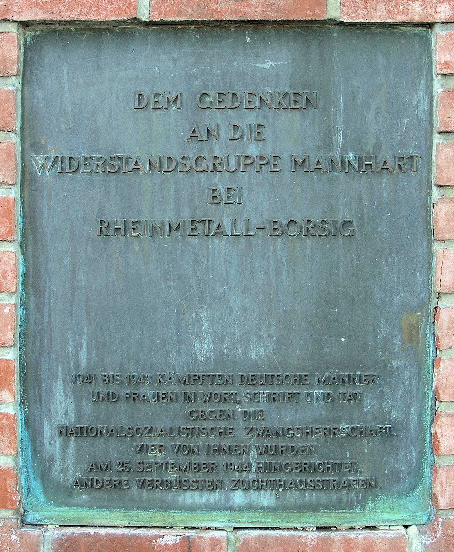
| current | 12:12, 23 July 2009 | | 1,480 × 1,798 (2.93 MB) | OTFW (talk | contribs) | {{Location|52|34|59|N|13|17|21|E|alt:40_source:exif_heading:?}} {{Information |Description={{de|1=Gedenktafel, Wiederstandsgruppe Mannhart, Berliner Str 26, Berlin-Reinickendorf, Deutschland}} {{en|1=Memorial pl |
You cannot overwrite this file.
File usage on Commons
The following 12 pages use this file:
- User:OTFW/Bilder/Gedenktafeln/M-R
- User:OTFW/Bilder/Gedenktafeln/Strassen/A-C
- User:OTFW/Bilder/Gedenktafeln/T-Z
- File:Gedenktafel Berliner Str 26 (Tegel) Widerstandsgruppe Mannhart2.jpg
- File:Gedenktafel Berliner Str 26 (Tegel) Widerstandsgruppe Mannhart3.jpg
- File:Gedenktafel Berliner Str 26 (Tegel) Widerstandsgruppe Mannhart4.jpg
- File:Gedenktafel Berliner Str 26 (Tegel) Wiederstandsgruppe Mannhart.JPG (file redirect)
_Wiederstandsgruppe_Mannhart.JPG&redirect=no)
File usage on other wikis
The following other wikis use this file:
- Usage on de.wikipedia.org
_Widerstandsgruppe_Mannhart.jpg&oldid=479406468)