File:Gedser-Rostock bridge.svg

Size of this PNG preview of this SVG file: 428 × 306 pixels. Other resolutions: 320 × 229 pixels | 640 × 458 pixels | 1,024 × 732 pixels | 1,280 × 915 pixels | 2,560 × 1,830 pixels.
Original file (SVG file, nominally 428 × 306 pixels, file size: 274 KB)
Captions
Captions
Add a one-line explanation of what this file represents
| Description |
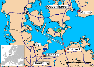
English: Map showing the route of the Gedser-Rostock Bridge
Deutsch: Vorgeschlagener Verlauf der Rostock-Gedser-Querung |
||
| Date | (UTC) | ||
| Source | File:Fehmarn-bridge.svg | ||
| Author |
File:Fehmarn-bridge.svg: Bowzer
|
||
| SVG development |
|
I, the copyright holder of this work, hereby publish it under the following licenses:
This file is licensed under the Creative Commons Attribution-Share Alike 3.0 Unported license.
- You are free:
- to share – to copy, distribute and transmit the work
- to remix – to adapt the work
- Under the following conditions:
- attribution – You must give appropriate credit, provide a link to the license, and indicate if changes were made. You may do so in any reasonable manner, but not in any way that suggests the licensor endorses you or your use.
- share alike – If you remix, transform, or build upon the material, you must distribute your contributions under the same or compatible license as the original.

|
Permission is granted to copy, distribute and/or modify this document under the terms of the GNU Free Documentation License, Version 1.2 or any later version published by the Free Software Foundation; with no Invariant Sections, no Front-Cover Texts, and no Back-Cover Texts. A copy of the license is included in the section entitled GNU Free Documentation License. |
You may select the license of your choice.
Original upload log
edit
This image is a derivative work of the following images:
- File:Fehmarn-bridge.svg licensed with Cc-by-sa-3.0, GFDL
- 2009-07-03T15:33:32Z Bowzer 428x306 (280245 Bytes) {{Information |Description={{en|1=Map showing the route of the Fehmarn Belt bridge}} |Source=Own work by uploader, created with GMT, using street data from other images in commons: * http://commons.wikimedia.org/wiki/Ima
Uploaded with derivativeFX
File history
Click on a date/time to view the file as it appeared at that time.
| Date/Time | Thumbnail | Dimensions | User | Comment | |
|---|---|---|---|---|---|
| current | 03:51, 21 June 2011 | | 428 × 306 (274 KB) | Indoor-Fanatiker (talk | contribs) | {{Information |Description={{en|Map showing the route of the Gedser-Rostock Bridge}} {{de|Vorgeschlagener Verlauf der Rostock-Gedser-Querung}} |Source=*File:Fehmarn-bridge.svg |Date=2011-06-21 03:44 (UTC) |Author=*File:Fehmarn-bridge.svg: [[Us |
You cannot overwrite this file.
File usage on Commons
There are no pages that use this file.