File:Geislinger, Jäger Steig Panorama.jpg

Size of this preview: 800 × 254 pixels. Other resolutions: 320 × 102 pixels | 640 × 203 pixels | 1,024 × 325 pixels | 1,280 × 407 pixels | 2,560 × 813 pixels | 7,237 × 2,299 pixels.
Original file (7,237 × 2,299 pixels, file size: 12.46 MB, MIME type: image/jpeg)
Captions
Captions
Add a one-line explanation of what this file represents
| Description |
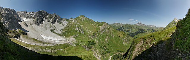
Deutsch: Panorama mit mehreren Bilder. Vom Geislinger Steig (auch Jägersteig genannt) richtet sich das Berg Panorama auf links die Nordflanke der Braunarlspitze, das Fürggele am Hochbergsattel (der Weg zweigt dort zur Biberacher Hütte ab), der Hochberg, die Hochgletscheralpe, im Hintergrund der Heiterberg, die mit Lawinenfangzäunen verbaute Höferspitze 2.131m, sowie der Große Widderstein 2.533m und das Geißhorn 2.366m in den Allgäuer Alpen Am rechten Bildrand die Juppenspitze. Durch das Felletal (Bildmitte) führt der Weg nach Schröcken. |
| Date | |
| Source | Own work |
| Author | böhringer friedrich |
| Permission (Reusing this file) |
I, the copyright holder of this work, hereby publish it under the following license: This file is licensed under the Creative Commons Attribution-Share Alike 2.5 Generic license.
|
This Photo was taken by Böhringer Friedrich.
|
Feel free to use my photos, but please mention me as the author and if you want send me a message. or (rufre@lenz-nenning.at) |
| Camera location | | View this and other nearby images on: OpenStreetMap |
|---|
| Annotations | This image is annotated: View the annotations at Commons |
File history
Click on a date/time to view the file as it appeared at that time.
| Date/Time | Thumbnail | Dimensions | User | Comment | |
|---|---|---|---|---|---|
| current | 19:07, 25 August 2009 | 7,237 × 2,299 (12.46 MB) | Böhringer (talk | contribs) | {{Information |Description= {{de| Panorama mit mehreren Bilder. Vom Geislinger Steig (auch Jägersteig genannt) richtet sich das Berg Panorama auf links die Nordflanke der Braunarlspitze, das Fürggele am Hochbergsattel (der Weg zwe |
You cannot overwrite this file.
File usage on Commons
There are no pages that use this file.