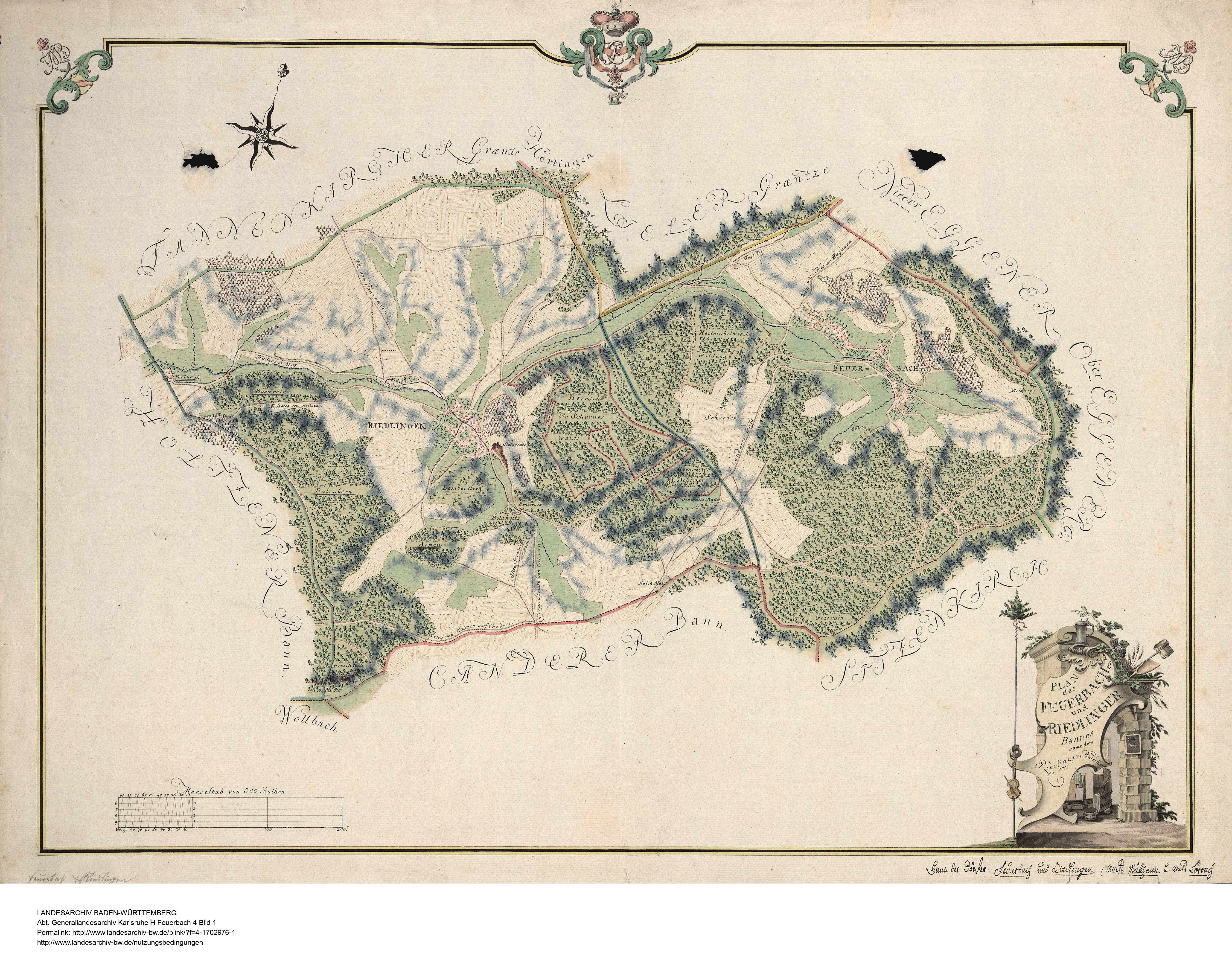
File:Gemarkung Feuerbach 1772.jpg
Size of this preview: 758 × 599 pixels. Other resolutions: 304 × 240 pixels | 607 × 480 pixels | 971 × 768 pixels | 1,280 × 1,012 pixels | 2,560 × 2,024 pixels | 5,351 × 4,231 pixels.
Original file (5,351 × 4,231 pixels, file size: 3.25 MB, MIME type: image/jpeg)
Captions
Captions
Add a one-line explanation of what this file represents
Summary
edit
| Description | Gemarkungspläne. Erste badische Landesaufnahme. Plan des Feuerbacher und Riedlinger Bannes samt dem Riedlinger Badhaus. |
| Date | |
| Source | Landesarchiv Baden-Württemberg. Generallandesarchiv Karlsruhe. H Feuerbach 4 [1] |
| Author | Erhardt |
Licensing
edit
|
This work is in the public domain in its country of origin and other countries and areas where the copyright term is the author's life plus 70 years or fewer. This work is in the public domain in the United States because it was published (or registered with the U.S. Copyright Office) before January 1, 1929. | |
| This file has been identified as being free of known restrictions under copyright law, including all related and neighboring rights. | |
File history
Click on a date/time to view the file as it appeared at that time.
| Date/Time | Thumbnail | Dimensions | User | Comment | |
|---|---|---|---|---|---|
| current | 10:00, 3 December 2022 | | 5,351 × 4,231 (3.25 MB) | Zieglhar (talk | contribs) | {{Information |Description=Gemarkungspläne. Erste badische Landesaufnahme. Plan des Feuerbacher und Riedlinger Bannes samt dem Riedlinger Badhaus. |Source=Landesarchiv Baden-Württemberg. Generallandesarchiv Karlsruhe. H Feuerbach 4 [http://www.landesarchiv-bw.de/plink/?f=4-1702976] |Date=1772 |Author=Erhardt |Permission= |other_versions= }} Feuerbach Category:Kandern-Feuerbach [[Category:Maps - 1. Badische Landesaufnahme im Landkreis Lörrach|Kandern-Fe... |
You cannot overwrite this file.
File usage on Commons
The following 2 pages use this file: