File:Gemeinden-frla.png

Size of this preview: 800 × 511 pixels. Other resolutions: 320 × 204 pixels | 640 × 409 pixels | 1,159 × 740 pixels.
Original file (1,159 × 740 pixels, file size: 51 KB, MIME type: image/png)
Captions
Captions
Add a one-line explanation of what this file represents
Summary
edit
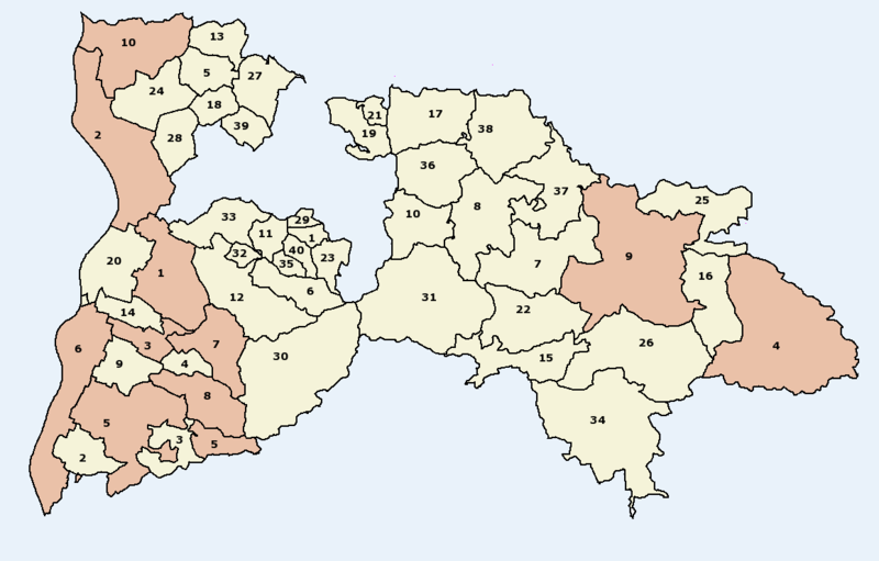
Übersicht über Städte (dunkel gefärbt) und Gemeinden (hell gefärbt) im Landkreis Breisgau-Hochschwarzwald
Die Nummern der Gemeinden und Städte sind alphabetisch nach den hochalemannischen Ortsnamen der Kommunen, nicht etwa der deutschen, da die Karte zur Verwendung in der alemannischen Wikipedia erstellt wurde.
Städte
edit
- Bad Krozingen / Bad Chrozige
- Breisach am Rhein / Brisach am Rhi
- Heitersheim / Heitersche
- Löffingen / Leffinge
- Müllheim (Baden) / Mülle
- Neuenburg am Rhein / Nöieburg am Rhi
- Staufen im Breisgau / Staufe im Brisgau
- Sulzburg
- Titisee-Neustadt / Titisee-Nöistadt
Gemeinden
edit
- Au (Breisgau) / Au (Brisgau)
- Auggen / Augge
- Badenweiler / Badewiler
- Ballrechten-Dottingen / Ballrächte-Dottige
- Bötzingen / Bötzige
- Bollschweil / Bollschwil
- Breitnau
- Buchenbach / Buechebach
- Buggingen / Bugginge
- Kirchzarten / Chilchzarte
- Ebringen / Ebringe
- Ehrenkirchen / Ehrechilche
- Eichstetten am Kaiserstuhl / Eichstette am Kaiserstuehl
- Eschbach (Markgräflerland) / Eschbe (Markgräflerland)
- Feldberg (Schwarzwald)
- Friedenweiler / Friidewiler
- Glottertal / Glodderdal
- Gottenheim / Gottene
- Gundelfingen im Breisgau / Gundelfinge im Brisgau
- Hartheim (Breisgau) / Harte (Brisgau)
- Heuweiler / Haiwiler
- Hinterzarten / Hinderzarte
- Horben (Schwarzwald) / Horbe (Schwarzwald)
- Ihringen / Ihringe
- Eisenbach (Hochschwarzwald) / Iisebach (Hochschwarzwald)
- Lenzkirch / Lenzchilche
- March (Breisgau) / March (Brisgau)
- Merdingen / Mardinge
- Merzhausen / Merzhuse
- Münstertal (Schwarzwald) / Münsterdal (Schwarzwald)
- Oberried (Breisgau) / Oberried (Brisgau)
- Pfaffenweiler / Pfaffewiler
- Schallstadt / Schallsched
- Schluchsee
- Sölden (Schwarzwald) / Sailede (Schwarzwald)
- Stegen (Dreisamtal) / Stäge (Drisamdal)
- St. Märgen / St. Märge
- St. Peter (Hochschwarzwald)
- Umkirch / Umchilche
- Wittnau (Breisgau) / Wittnau (Brisgau)
Summary
edit
- Karte selbst erstellt von user:w-j-s
Licensing
edit

|
Permission is granted to copy, distribute and/or modify this document under the terms of the GNU Free Documentation License, Version 1.2 or any later version published by the Free Software Foundation; with no Invariant Sections, no Front-Cover Texts, and no Back-Cover Texts. A copy of the license is included in the section entitled GNU Free Documentation License. |
| This file is licensed under the Creative Commons Attribution-Share Alike 3.0 Unported license. | ||
| ||
| This licensing tag was added to this file as part of the GFDL licensing update. |
File history
Click on a date/time to view the file as it appeared at that time.
| Date/Time | Thumbnail | Dimensions | User | Comment | |
|---|---|---|---|---|---|
| current | 17:18, 19 February 2006 | | 1,159 × 740 (51 KB) | W-j-s (talk | contribs) | * Übersicht über Städte (dunkel gefärbt) und Gemeinden (hell gefärbt) im Landkreis Breisgau-Hochschwarzwald * Karte selbst erstellt von user:w-j-s |
You cannot overwrite this file.
File usage on Commons
The following page uses this file:
File usage on other wikis
The following other wikis use this file:
- Usage on als.wikipedia.org
- Usage on pl.wikipedia.org