File:Genes mirror geography in the British Isles.PNG

Size of this preview: 722 × 600 pixels. Other resolutions: 289 × 240 pixels | 578 × 480 pixels | 925 × 768 pixels | 1,233 × 1,024 pixels | 2,466 × 2,048 pixels | 4,468 × 3,711 pixels.
Original file (4,468 × 3,711 pixels, file size: 1.13 MB, MIME type: image/png)
Captions
Captions
Add a one-line explanation of what this file represents
Summary
edit| Description |
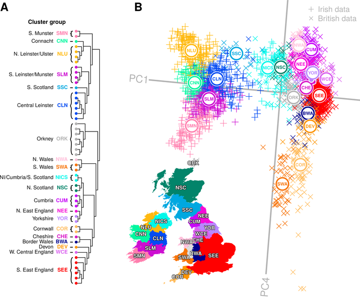
English: Genes mirror geography in the British Isles.
(A) fineSTRUCTURE clustering dendrogram for combined Irish and British data. Data principally split into Irish and British groups before subdividing into a total of 50 distinct clusters, which are combined into cluster groups for clusters that formed clades in the dendrogram, overlapped in principal component space (B) and were sampled from regions that are geographically contiguous. Names and labels follow the geographical provenance for the majority of data within the cluster group. Details for each cluster in the dendrogram are provided in S2 Fig. (B) Principal component analysis (PCA) of haplotypic similarity based on the ChromoPainter coancestry matrix, coloured by cluster group with their median locations labelled. We have chosen to present PC1 versus PC4 here as these components capture new information regarding correlation between haplotypic variation across Britain and Ireland and geography, while PC2 and PC3 (Fig 4) capture previously reported splitting for Orkney and Wales, respectively, from Britain [7]. A map of Ireland and Britain is shown for comparison, coloured by sampling regions for cluster groups, the boundaries of which are defined based on the Nomenclature of Territorial Units for Statistics (NUTS 2010), with some regions combined. Sampling regions are coloured by the cluster group with the majority presence in the sampling region; some sampling regions have significant minority cluster group representations as well, for example the Northern Ireland sampling region (UKN0; NUTS 2010) is majorly explained by the NICS cluster group but also has significant representation from the NLU cluster group. The PCA plot has been rotated clockwise by 5 degrees to highlight its similarity with the geographical map of the Ireland and Britain. NI, Northern Ireland; PC, principal component. Cluster groups that share names with groups from Fig 1 (NLU; SMN; CLN; CNN) have an average of 80% of their samples shared with the initial cluster groups. The map and administrative boundaries were produced using data from the database of Global Administrative Areas (GADM; https://gadm.org), note some boundaries have been subsumed or modified to better reflect sampling regions. |
| Date | Published: January 25, 2018 |
| Source | Byrne RP, Martiniano R, Cassidy LM, Carrigan M, Hellenthal G, Hardiman O, et al. (2018) Insular Celtic population structure and genomic footprints of migration. PLoS Genet 14(1): e1007152. https://doi.org/10.1371/journal.pgen.1007152 |
| Author | Ross P. Byrne, Rui Martiniano, Lara M. Cassidy, Matthew Carrigan, Garrett Hellenthal, Orla Hardiman, Daniel G. Bradley, Russell L. McLaughlin |
| Other versions |
|


Licensing
edit
This file is licensed under the Creative Commons Attribution 4.0 International license.
- You are free:
- to share – to copy, distribute and transmit the work
- to remix – to adapt the work
- Under the following conditions:
- attribution – You must give appropriate credit, provide a link to the license, and indicate if changes were made. You may do so in any reasonable manner, but not in any way that suggests the licensor endorses you or your use.
File history
Click on a date/time to view the file as it appeared at that time.
| Date/Time | Thumbnail | Dimensions | User | Comment | |
|---|---|---|---|---|---|
| current | 19:51, 16 November 2019 | | 4,468 × 3,711 (1.13 MB) | Was a bee (talk | contribs) | {{Information |Description={{en|1=Genes mirror geography in the British Isles. (A) fineSTRUCTURE clustering dendrogram for combined Irish and British data. Data principally split into Irish and British groups before subdividing into a total of 50 distinct clusters, which are combined into cluster groups for clusters that formed clades in the dendrogram, overlapped in principal component space (B) and were sampled from regions that are geographically contiguous. Names and labels follow the ge... |
You cannot overwrite this file.
File usage on Commons
The following 4 pages use this file: