File:Gennes (Maine-et-Loire) (14303358180).jpg

Original file (4,928 × 3,264 pixels, file size: 12.64 MB, MIME type: image/jpeg)
Captions
Captions
Summary edit
_(14303358180).jpg&action=edit§ion=1)
| Description |
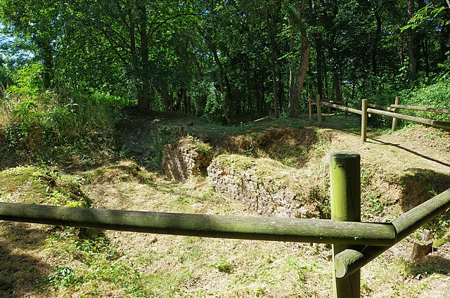
Amphithéâtre Gallo-Romain de Gennes (Maine-et-Loire). C'est un demi amphithéâtre adossé à la colline de Mazerolles au sud du bourg de Gennes. Des fouilles récentes montrent que cet amphithéâtre construit à la fin du pemier siècle fut utilisé jusqu'au début du troisième siècle (comme l'indique les éléments mobiliers, monnaies et poteries, retrouvés). En 1837, des vestiges du grand mur sont signalés par l'abbé Pinson, dans la colline de Mazerolles. Les premières fouilles débutent en 1862 sous l direction de Charles d'Achon. En 1873 et 1883, avec l'aide de monsieur Paul de Farcy, quelques murs sont mis au jour. En 1898 et 1901, une grande partie du mur d'enceinte sera dégagée. Le premier plan du site est réalisé par G. Dufour en 1931. En 1980, la municipalité de Gennes devient propriétaire du site. De nouvelles fouilles sont effectuées de 1985 à 1990. Certaines parties ont été ré-enfouies par mesure conservatoire.
This is a semi amphitheater backs onto the hill of Mazerolles south of the town of Gennes. Recent excavations indicate that this amphitheater built in the late 1st century was used until the early third century (as indicated movable Elements, coins and pottery, find yourself). In 1837, the remains of the Great Wall are reported by Father Finch, in the hill of Mazerolles. The first excavations began in 1862 under the direction of Charles Achon. In 1873 and 1883, with the help of Mr. Paul de Farcy, some walls are uncovered. In 1898 and 1901, much of the enclosure wall is clear. The foreground on the site is carried out by G. Dufour in 1931. In 1980, the municipality of Gennes becomes the owner of the site. New excavations are carried out from 1985 to 1990. Portions were re-buried by protective measures. |
| Date | Taken on 19 June 2014, 16:16 |
| Source | Gennes (Maine-et-Loire) |
| Author | Daniel Jolivet |
| Camera location | | View this and other nearby images on: OpenStreetMap |
|---|
_(14303358180).jpg¶ms=047.335219_N_-000.237395_E_globe:Earth_type:camera_source:Flickr_&language=en)
Licensing edit
_(14303358180).jpg&action=edit§ion=2)
- You are free:
- to share – to copy, distribute and transmit the work
- to remix – to adapt the work
- Under the following conditions:
- attribution – You must give appropriate credit, provide a link to the license, and indicate if changes were made. You may do so in any reasonable manner, but not in any way that suggests the licensor endorses you or your use.
| This image was originally posted to Flickr by sybarite48 at https://flickr.com/photos/26082117@N07/14303358180 (archive). It was reviewed on 28 November 2017 by FlickreviewR 2 and was confirmed to be licensed under the terms of the cc-by-2.0. |
File history
Click on a date/time to view the file as it appeared at that time.
| Date/Time | Thumbnail | Dimensions | User | Comment | |
|---|---|---|---|---|---|
| current | 10:08, 28 November 2017 | | 4,928 × 3,264 (12.64 MB) | Thesupermat2 (talk | contribs) | Transferred from Flickr via Flickr2Commons |
You cannot overwrite this file.
File usage on Commons
There are no pages that use this file.
_(14303358180).jpg&oldid=783535788)