File:Geoga Bridge map.png
Size of this preview: 800 × 437 pixels. Other resolutions: 320 × 175 pixels | 640 × 350 pixels | 1,041 × 569 pixels.
Original file (1,041 × 569 pixels, file size: 122 KB, MIME type: image/png)
Captions
Captions
Add a one-line explanation of what this file represents
Summary edit
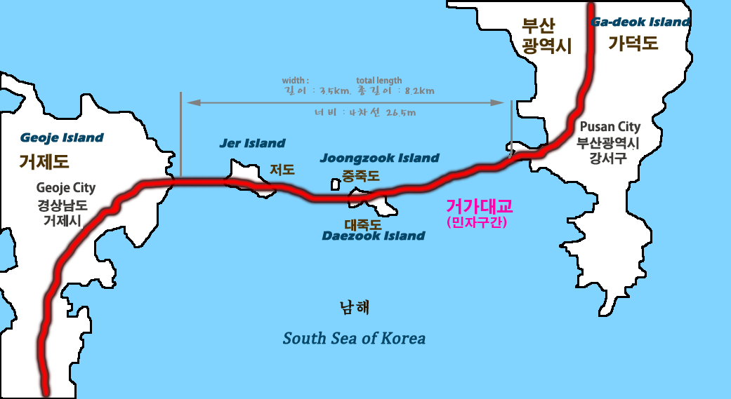
| Description |
English: Map of Busan–Geoje Fixed Link roadway bridge-tunnel system |
||
| Date | |||
| Source | ko:파일:거가대교 지도.png | ||
| Author | self-made | ||
| Other versions |
|

| Object location | | View this and other nearby images on: OpenStreetMap |
|---|
Licensing edit
| I, the copyright holder of this work, release this work into the public domain. This applies worldwide. In some countries this may not be legally possible; if so: I grant anyone the right to use this work for any purpose, without any conditions, unless such conditions are required by law. |
File history
Click on a date/time to view the file as it appeared at that time.
| Date/Time | Thumbnail | Dimensions | User | Comment | |
|---|---|---|---|---|---|
| current | 11:19, 10 November 2010 | | 1,041 × 569 (122 KB) | Asfreeas (talk | contribs) | {{Information |Description=Map of newly made Geoga Bridge |Source=http://ko.wikipedia.org/wiki/%ED%8C%8C%EC%9D%BC:%EA%B1%B0%EA%B0%80%EB%8C%80%EA%B5%90_%EC%A7%80%EB%8F%84.png |Date=2010-11-10 |Author=self-made |Permission=see below |other_versions= }} [[C |
You cannot overwrite this file.
File usage on Commons
The following 2 pages use this file:
File usage on other wikis
The following other wikis use this file:
- Usage on cs.wikipedia.org
- Usage on de.wikipedia.org
- Usage on en.wikipedia.org
- Usage on fr.wikipedia.org
- Usage on ja.wikipedia.org
- Usage on nl.wikipedia.org
- Usage on no.wikipedia.org
- Usage on www.wikidata.org
- Usage on zh-yue.wikipedia.org
- Usage on zh.wikipedia.org