File:Geologic Map of Georgia.png
Size of this preview: 528 × 600 pixels. Other resolutions: 211 × 240 pixels | 422 × 480 pixels | 676 × 768 pixels | 901 × 1,024 pixels | 1,802 × 2,048 pixels | 2,640 × 3,000 pixels.
Original file (2,640 × 3,000 pixels, file size: 1.31 MB, MIME type: image/png)
Captions
Captions
Add a one-line explanation of what this file represents
| Description | |
| Source | |
| Author |
Licensing edit
This image is in the public domain in the United States because it only contains materials that originally came from the United States Geological Survey, an agency of the United States Department of the Interior. For more information, see the official USGS copyright policy.
|
Original upload log edit
The original description page was here. All following user names refer to en.wikipedia.
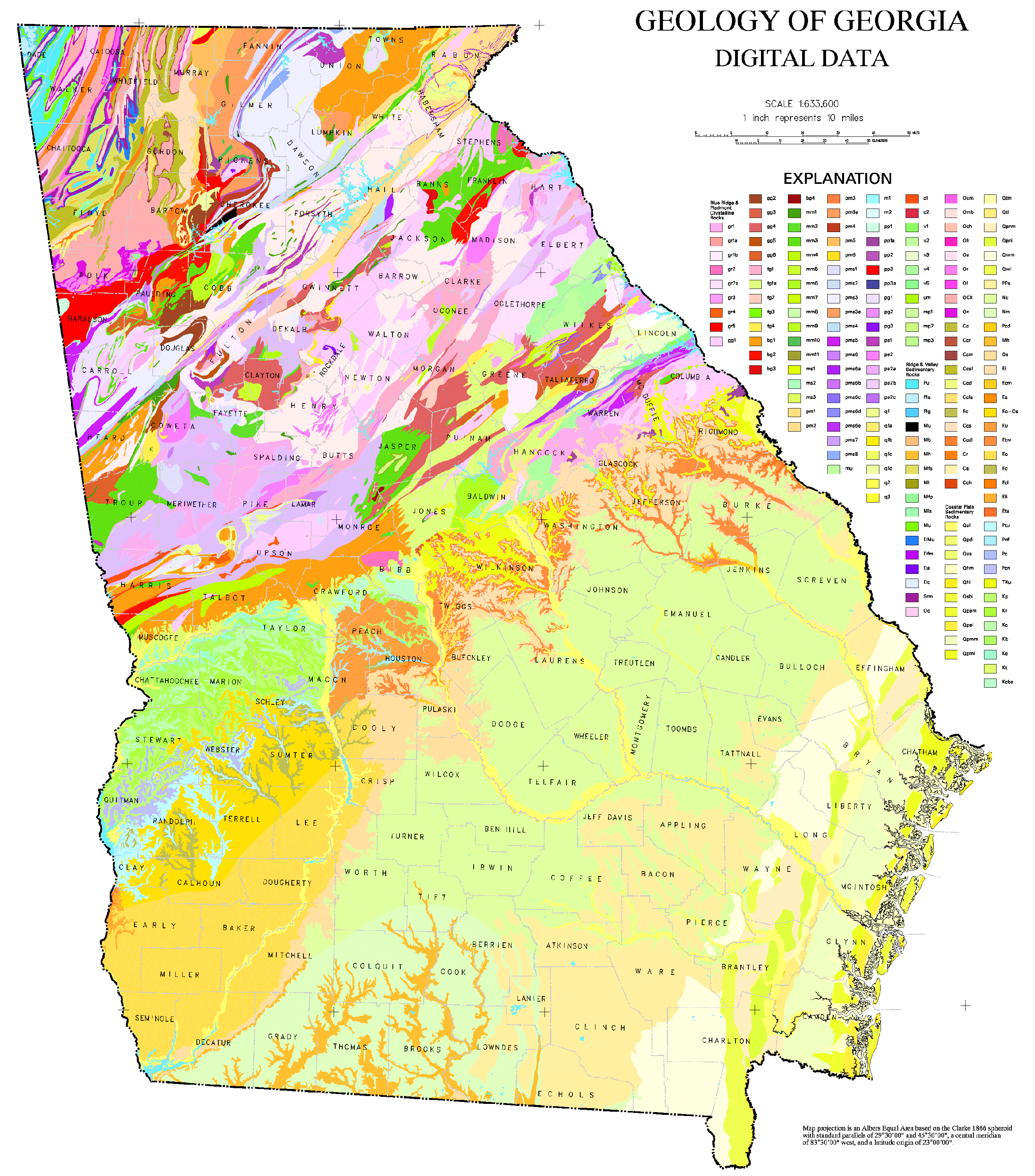
- 2006-10-24 21:50 Tlmclain 3086×3450× (1836224 bytes) The map compilation was published by the Georgia Geologic Survey in 1976 as the Geologic Map of [[Georgia (U.S. State)|Georgia]]. Source: [http://csat.er.usgs.gov/statewide/layers/geology.html USGS] {{PD-USGov-Interior-USGS}} [[Category:Georgia (U.S. sta
File history
Click on a date/time to view the file as it appeared at that time.
| Date/Time | Thumbnail | Dimensions | User | Comment | |
|---|---|---|---|---|---|
| current | 17:00, 27 March 2021 | | 2,640 × 3,000 (1.31 MB) | User-duck (talk | contribs) | Cropped borders using CropTool with lossless mode. |
| 20:50, 9 April 2009 |  | 3,086 × 3,450 (1.75 MB) | File Upload Bot (Magnus Manske) (talk | contribs) | {{BotMoveToCommons|en.wikipedia|year={{subst:CURRENTYEAR}}|month={{subst:CURRENTMONTHNAME}}|day={{subst:CURRENTDAY}}}} {{Information |Description={{en|The map compilation was published by the Georgia Geologic Survey in 1976 as the Geologic Map of [[:en:G |
You cannot overwrite this file.
File usage on Commons
The following page uses this file:
File usage on other wikis
The following other wikis use this file:
- Usage on en.wikipedia.org
- Thematic map
- Field (geography)
- User:Tlmclain
- Geology of Georgia (U.S. state)
- Geologic mapping of Georgia (U.S. state)
- User:Abyssal/Portal:Ordovician
- User:Abyssal/Portal:Devonian
- User:Abyssal/Portal:Cambrian/Science, culture, and economics articles/6
- User:Abyssal/Portal:Ordovician/Science, culture, and economics articles/4
- User:Abyssal/Portal:Silurian/Science, culture, and economics articles/4
- User:Abyssal/Portal:Devonian/Science, culture, and economics articles/4
- User:Abyssal/Portal:Carboniferous/Science, culture, and economics articles/7
- User:Abyssal/Portal:Triassic/Science, culture, and economics articles/7
- User:Abyssal/Portal:Paleogene/Science, culture, and economics articles/9
- User:Abyssal/Portal:Neogene/Science, culture, and economics articles/9
- User:Abyssal/Portal:Cenozoic/Science, culture, and economics articles/9
- User:Abyssal/Portal:Quaternary/Science, culture, and economics articles
- User:Abyssal/Portal:Quaternary/Science, culture, and economics articles/9
- Chorochromatic map
- Qualitative geography
- Usage on ko.wikipedia.org
- Usage on ru.wikipedia.org
- Usage on sk.wikipedia.org
- Usage on uk.wikipedia.org
- Usage on www.wikidata.org
- Usage on zh.wikipedia.org