File:Geological map marmara island - hochstetter.jpg

Size of this preview: 531 × 599 pixels. Other resolutions: 213 × 240 pixels | 425 × 480 pixels | 681 × 768 pixels | 908 × 1,024 pixels | 1,816 × 2,048 pixels | 3,306 × 3,729 pixels.
Original file (3,306 × 3,729 pixels, file size: 606 KB, MIME type: image/jpeg)
Captions
Captions
Add a one-line explanation of what this file represents
Summary
edit
| Description |
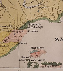
English: Geological map with Marmara Island (Ferdinand von Hochstetter 1870)
Deutsch: Geologische Karte mit Marmara-Insel (Ferdinand von Hochstetter 1870)
Français : Carte géologique avec l'île de Marmara (Ferdinand de Hochstetter 1870)
Русский: Геологическая карта в oстрове Мармара (Фердинанд фон Хохштетер 1870 г.) |
| Date | |
| Source | Own work |
| Author | Lysippos |
Licensing
edit
| I, the copyright holder of this work, release this work into the public domain. This applies worldwide. In some countries this may not be legally possible; if so: I grant anyone the right to use this work for any purpose, without any conditions, unless such conditions are required by law. |
File history
Click on a date/time to view the file as it appeared at that time.
| Date/Time | Thumbnail | Dimensions | User | Comment | |
|---|---|---|---|---|---|
| current | 11:14, 6 July 2020 | | 3,306 × 3,729 (606 KB) | Vogelbeeren (talk | contribs) | Cropped 57 % horizontally, 16 % vertically using CropTool with precise mode. |
| 18:46, 20 July 2008 |  | 7,684 × 4,427 (1.56 MB) | Lysippos (talk | contribs) | {{Information |Description={{en|1=Geological map with Marmara Island (Hochstetter 1870)}} {{de|1=Geologische Karte mit Marmara-Insel (Hochstetter 1870)}} {{fr|1=Carte géologique avec l'île de Marmara (Hochstetter 1870)}} {{ru|1=Геологическа� |
You cannot overwrite this file.
File usage on Commons
There are no pages that use this file.
File usage on other wikis
The following other wikis use this file:
- Usage on cs.wikipedia.org
- Usage on de.wikipedia.org