File:Geological map showing distribution of the Silver Creek hydraulic limestone of southeastern Indiana. - DPLA - 2e97669abde560bf5fb9b1402575ecfb.jpg

Size of this preview: 495 × 600 pixels. Other resolutions: 198 × 240 pixels | 396 × 480 pixels | 634 × 768 pixels | 845 × 1,024 pixels | 1,691 × 2,048 pixels | 4,526 × 5,482 pixels.
Original file (4,526 × 5,482 pixels, file size: 3.26 MB, MIME type: image/jpeg)
Captions
Captions
Add a one-line explanation of what this file represents
Summary
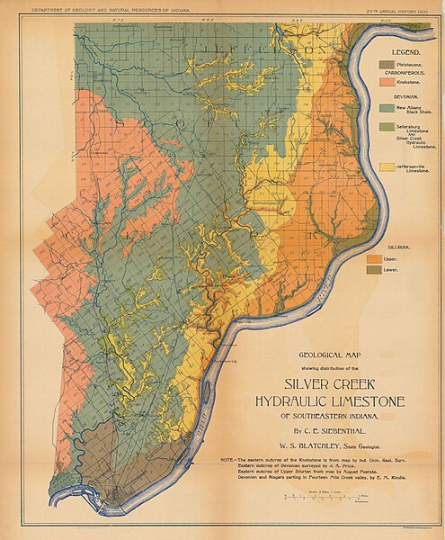
edit| Geological map showing distribution of the Silver Creek hydraulic limestone of southeastern Indiana.
( |
|||||||||||||||||
|---|---|---|---|---|---|---|---|---|---|---|---|---|---|---|---|---|---|
| Creator | Siebenthal, C. E; Blatchley, W. S; Department of Geology and Natural Resources of Indiana | ||||||||||||||||
| Title |
Geological map showing distribution of the Silver Creek hydraulic limestone of southeastern Indiana. |
||||||||||||||||
| Description |
25th annual report; Scale : 2 miles=1 inch |
||||||||||||||||
| Date | 1900 | ||||||||||||||||
| Collection |
|
||||||||||||||||
| Source/Photographer |
|
||||||||||||||||
| Permission (Reusing this file) |
Copyright determination made by Indiana University Libraries ( Q58241552) using RightsStatements.org
|
||||||||||||||||


File history
Click on a date/time to view the file as it appeared at that time.
| Date/Time | Thumbnail | Dimensions | User | Comment | |
|---|---|---|---|---|---|
| current | 00:18, 9 April 2023 | | 4,526 × 5,482 (3.26 MB) | DPLA bot (talk | contribs) | Uploading DPLA ID dpla:2e97669abde560bf5fb9b1402575ecfb |
You cannot overwrite this file.
File usage on Commons
The following page uses this file: