File:Geopark Barrandien panorama.jpg

Size of this preview: 800 × 278 pixels. Other resolutions: 320 × 111 pixels | 640 × 222 pixels | 2,000 × 695 pixels.
Original file (2,000 × 695 pixels, file size: 627 KB, MIME type: image/jpeg)
Captions
Captions
Add a one-line explanation of what this file represents
Summary edit
| Description |
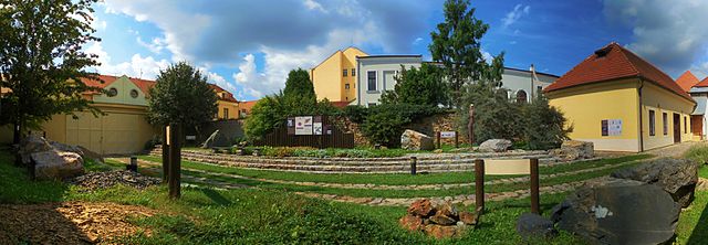
Čeština: Geopark Barrandien - panoramatický pohled na venkovní expozici typických hornin Barrandienu, Muzeum Českého krasu v Berouně. |
| Date | |
| Source | Own work |
| Author | Pavel Bokr |
| Camera location | | View this and other nearby images on: OpenStreetMap |
|---|
Geopark Barrandien umístěný ve dvoře Muzea Českého krasu v Berouně.
Licensing edit
I, the copyright holder of this work, hereby publish it under the following license:
This file is licensed under the Creative Commons Attribution 4.0 International license.
- You are free:
- to share – to copy, distribute and transmit the work
- to remix – to adapt the work
- Under the following conditions:
- attribution – You must give appropriate credit, provide a link to the license, and indicate if changes were made. You may do so in any reasonable manner, but not in any way that suggests the licensor endorses you or your use.
File history
Click on a date/time to view the file as it appeared at that time.
| Date/Time | Thumbnail | Dimensions | User | Comment | |
|---|---|---|---|---|---|
| current | 18:17, 17 February 2017 | 2,000 × 695 (627 KB) | Trilobit (talk | contribs) | User created page with UploadWizard |
You cannot overwrite this file.
File usage on Commons
There are no pages that use this file.
File usage on other wikis
The following other wikis use this file:
- Usage on cs.wikipedia.org