File:Georgenkirche Wismar.jpg

Size of this preview: 480 × 599 pixels. Other resolutions: 192 × 240 pixels | 384 × 480 pixels | 657 × 820 pixels.
Original file (657 × 820 pixels, file size: 538 KB, MIME type: image/jpeg)
Captions
Captions
Add a one-line explanation of what this file represents
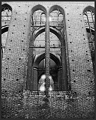
| Description | Ruine der Georgenkirche in Wismar in den 1980er Jahren |
| Date | 16.01.2009 (Upload) |
| Source | Own work |
| Author | Ch. Pagenkopf |
| Camera location | | View this and other nearby images on: OpenStreetMap |
|---|
This file is licensed under the Creative Commons Attribution 3.0 Unported license.
- You are free:
- to share – to copy, distribute and transmit the work
- to remix – to adapt the work
- Under the following conditions:
- attribution – You must give appropriate credit, provide a link to the license, and indicate if changes were made. You may do so in any reasonable manner, but not in any way that suggests the licensor endorses you or your use.
File history
Click on a date/time to view the file as it appeared at that time.
| Date/Time | Thumbnail | Dimensions | User | Comment | |
|---|---|---|---|---|---|
| current | 19:35, 17 January 2009 | | 657 × 820 (538 KB) | Chpagenkopf (talk | contribs) | {{Information |Description=Ruine der Georgenkirche in Wismar in den 1980er Jahren |Source=own work |Date=16.01.2009 (Upload) |Author=Ch. Pagenkopf }} {{Location dec|53.8909278|11.4605194}} {{GFDL}} Category:Churches in Wismar <!- |
You cannot overwrite this file.
File usage on Commons
There are no pages that use this file.
File usage on other wikis
The following other wikis use this file:
- Usage on pl.wikipedia.org