File:Geostationaryjava3D.gif
No higher resolution available.
Geostationaryjava3D.gif (220 × 220 pixels, file size: 227 KB, MIME type: image/gif, looped, 183 frames, 14 s)
Captions
Captions
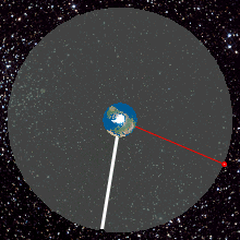
Top View of Geostationary orbit
Summary edit
| Description |
English: Top View of Geostationary orbit. To an observer on the rotating Earth (Africa on the Earth ), the satellite appears stationary in the sky as shown by the yellow radius. A red satellite is also geostationary above its own point on the Earth (Singapore)
http://weelookang.blogspot.com/2010/07/ejs-open-source-geostationary-satellite.html |
| Date | |
| Source | Own work |
| Author | Lookang many thanks to author of original simulation = Francisco Esquembre author of Easy Java Simulation = Francisco Esquembre |
Licensing edit
I, the copyright holder of this work, hereby publish it under the following license:
This file is licensed under the Creative Commons Attribution-Share Alike 3.0 Unported license.
- You are free:
- to share – to copy, distribute and transmit the work
- to remix – to adapt the work
- Under the following conditions:
- attribution – You must give appropriate credit, provide a link to the license, and indicate if changes were made. You may do so in any reasonable manner, but not in any way that suggests the licensor endorses you or your use.
- share alike – If you remix, transform, or build upon the material, you must distribute your contributions under the same or compatible license as the original.
File history
Click on a date/time to view the file as it appeared at that time.
| Date/Time | Thumbnail | Dimensions | User | Comment | |
|---|---|---|---|---|---|
| current | 02:45, 12 June 2013 | | 220 × 220 (227 KB) | Lookang (talk | contribs) | updated to 2013 version |
| 01:22, 27 June 2011 |  | 220 × 220 (480 KB) | Lookang (talk | contribs) | Geostationary orbit.To an observer on the rotating Earth (fixed point on the Earth), the satellite appears stationary in the sky. A red satellite is also geostationary above its own point on Earth. Top Down View | |
| 01:14, 27 June 2011 |  | 280 × 280 (677 KB) | Lookang (talk | contribs) | trying to make the thumbnail animated by using comtasia 7 | |
| 01:08, 27 June 2011 |  | 280 × 280 (624 KB) | Lookang (talk | contribs) | Geostationary orbit.To an observer on the rotating Earth (fixed point on the Earth), the satellite appears stationary in the sky. A red satellite is also geostationary above its own point on Earth. Top Down View | |
| 01:06, 27 June 2011 |  | 300 × 300 (625 KB) | Lookang (talk | contribs) | Geostationary orbit.To an observer on the rotating Earth (fixed point on the Earth), the satellite appears stationary in the sky. A red satellite is also geostationary above its own point on Earth. Top Down View. | |
| 00:57, 27 June 2011 |  | 300 × 300 (653 KB) | Lookang (talk | contribs) |
You cannot overwrite this file.
File usage on Commons
The following page uses this file:
File usage on other wikis
The following other wikis use this file:
- Usage on af.wikipedia.org
- Usage on an.wikipedia.org
- Usage on ar.wikipedia.org
- Usage on ast.wikipedia.org
- Usage on bn.wikipedia.org
- Usage on bs.wikipedia.org
- Usage on ca.wikipedia.org
- Usage on en.wikipedia.org
- Usage on es.wikipedia.org
- Usage on et.wikipedia.org
- Usage on fa.wikipedia.org
- Usage on gl.wikipedia.org
- Usage on he.wikipedia.org
- Usage on hi.wikipedia.org
- Usage on hr.wikipedia.org
- Usage on hu.wikipedia.org
- Usage on hy.wikipedia.org
- Usage on io.wikipedia.org
- Usage on kn.wikipedia.org
- Usage on ml.wikipedia.org
- Usage on ms.wikipedia.org
- Usage on pl.wikipedia.org
- Usage on pnb.wikipedia.org
- Usage on pt.wikipedia.org
- Usage on ru.wikipedia.org
- Usage on ru.wikinews.org
- Usage on simple.wikipedia.org
- Usage on si.wikipedia.org
- Usage on sl.wikipedia.org
- Usage on sr.wikipedia.org
- Usage on ta.wikipedia.org
- Usage on te.wikipedia.org
- Usage on tg.wikipedia.org
- Usage on th.wikipedia.org
- Usage on ur.wikipedia.org
- Usage on vi.wikipedia.org
- Usage on www.wikidata.org
- Usage on zh-yue.wikipedia.org
- Usage on zh.wikipedia.org