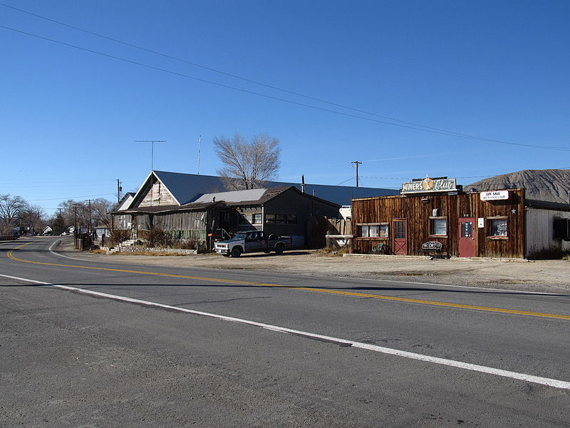
File:Gerlach, Nevada (11128521024).jpg

Original file (4,000 × 3,000 pixels, file size: 2.81 MB, MIME type: image/jpeg)
Captions
Captions
Summary edit
| DescriptionGerlach, Nevada (11128521024).jpg |
Gerlach, Nevada is a census-designated place (CDP) in Washoe County, Nevada, United States. The population was 206 at the 2010 census. It is part of the Reno–Sparks Metropolitan Statistical Area. Prior to 2010, Gerlach was part of the Gerlach–Empire census-designated place. The town of Empire is now a separate CDP. The next nearest town, Nixon, is 60 miles (100 km) to the south on a reservation owned by the Pyramid Lake Paiute Tribe. The Fly Geyser and Three Buddhas geysers are both located near Gerlach. The economy of Gerlach focuses on tourism in the nearby Black Rock Desert, and hunting. Gypsum mining was the historic staple of the local economy until 2011. Nearby Empire was a company town of the United States Gypsum Corporation (USG) until the plant closed on January 31, 2011, eliminating 95 jobs. The other major industries are a Union Pacific switching station in Gerlach and public services of Washoe County, which includes its roads department and a K–12 public school owned by the Washoe County School District; the future of the Gerlach K–12 School is unknown, as it is estimated that after the gypsum plant closes only around a dozen children will remain in Gerlach. Many of the inhabitants of Gerlach are elderly retirees. Many people in Gerlach also have small private businesses. Many are Internet-based, due to the town's remote location. Hunters from all over the west travel to Gerlach to hunt a wide variety of game such as chukar, geese, deer, antelope, etc. Joe's Gerlach Club hosts an annual chukar feed in late January. Bruno's restaurant hosts several other private parties in a large room in the back which is available for rent. Since 1991, Burning Man, a week long countercultural festival with 56,149 participants (as of 2012), has been held nearby. Due to the appearance and actions of many of the participants, local enthusiasm is mixed, but the event is responsible for around 20% of the sales at the few commercial establishments in the area, which include the closest permanent fuel and grocery stops to the event site. The Black Rock Desert is also the site of many other recreational activities, organized and otherwise, throughout the year. en.wikipedia.org/wiki/Gerlach,_Nevada en.wikipedia.org/wiki/Wikipedia:Text_of_Creative_Commons_... |
| Date | |
| Source | Gerlach, Nevada |
| Author | Ken Lund from Reno, Nevada, USA |
| Camera location | 40° 39′ 06.41″ N, 119° 21′ 16.13″ W | View this and other nearby images on: OpenStreetMap |
|---|
Licensing edit
- You are free:
- to share – to copy, distribute and transmit the work
- to remix – to adapt the work
- Under the following conditions:
- attribution – You must give appropriate credit, provide a link to the license, and indicate if changes were made. You may do so in any reasonable manner, but not in any way that suggests the licensor endorses you or your use.
- share alike – If you remix, transform, or build upon the material, you must distribute your contributions under the same or compatible license as the original.
| This image was originally posted to Flickr by Ken Lund at https://flickr.com/photos/75683070@N00/11128521024. It was reviewed on 5 December 2015 by FlickreviewR and was confirmed to be licensed under the terms of the cc-by-sa-2.0. |
5 December 2015
File history
Click on a date/time to view the file as it appeared at that time.
| Date/Time | Thumbnail | Dimensions | User | Comment | |
|---|---|---|---|---|---|
| current | 22:04, 5 December 2015 |  | 4,000 × 3,000 (2.81 MB) | INeverCry (talk | contribs) | Transferred from Flickr via Flickr2Commons |
You cannot overwrite this file.
File usage on Commons
There are no pages that use this file.
Metadata
This file contains additional information such as Exif metadata which may have been added by the digital camera, scanner, or software program used to create or digitize it. If the file has been modified from its original state, some details such as the timestamp may not fully reflect those of the original file. The timestamp is only as accurate as the clock in the camera, and it may be completely wrong.
| Camera manufacturer | Canon |
|---|---|
| Camera model | Canon PowerShot SX130 IS |
| Exposure time | 1/1,000 sec (0.001) |
| F-number | f/3.5 |
| ISO speed rating | 80 |
| Date and time of data generation | 03:17, 29 November 2013 |
| Lens focal length | 6.933 mm |
| Orientation | Normal |
| Horizontal resolution | 180 dpi |
| Vertical resolution | 180 dpi |
| File change date and time | 03:17, 29 November 2013 |
| Y and C positioning | Co-sited |
| Exif version | 2.3 |
| Date and time of digitizing | 03:17, 29 November 2013 |
| Meaning of each component |
|
| Image compression mode | 3 |
| APEX shutter speed | 9.96875 |
| APEX aperture | 3.625 |
| APEX exposure bias | −0.33333333333333 |
| Maximum land aperture | 3.625 APEX (f/3.51) |
| Metering mode | Pattern |
| Flash | Flash did not fire, compulsory flash suppression |
| Supported Flashpix version | 1 |
| Color space | sRGB |
| Focal plane X resolution | 16,393.442622951 |
| Focal plane Y resolution | 16,393.442622951 |
| Focal plane resolution unit | inches |
| Sensing method | One-chip color area sensor |
| File source | Digital still camera |
| Custom image processing | Normal process |
| Exposure mode | Manual exposure |
| White balance | Auto white balance |
| Digital zoom ratio | 1 |
| Scene capture type | Landscape |
| Rating (out of 5) | 0 |