File:Germany Levensau Karte.png

Size of this preview: 800 × 295 pixels. Other resolutions: 320 × 118 pixels | 640 × 236 pixels | 1,024 × 378 pixels | 2,738 × 1,010 pixels.
Original file (2,738 × 1,010 pixels, file size: 6.17 MB, MIME type: image/png)
Captions
Captions
Add a one-line explanation of what this file represents
Summary edit
| Description |
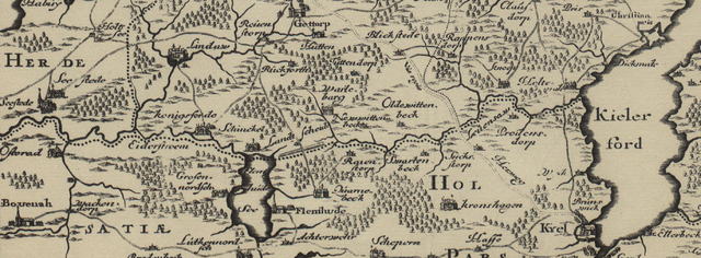
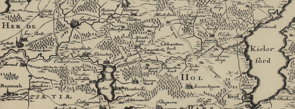
English: Map of the "Levensau" in the area "Dänischer Wohld" in the district "Rendsburg-Eckernförde" in the county "Schleswig-Holstein" in North-Germany |
| Date | |
| Source | "Landtcarte Uon dem Daenischen Walde" in "Neuwe Landesbeschreibung Der Zwey Herzogthümer Schleswich Vnd Holstein" |
| Author | Johannes Mejer, Caspar Danckwerth |
Licensing edit
|
This is a faithful photographic reproduction of a two-dimensional, public domain work of art. The work of art itself is in the public domain for the following reason:
The official position taken by the Wikimedia Foundation is that "faithful reproductions of two-dimensional public domain works of art are public domain".
This photographic reproduction is therefore also considered to be in the public domain in the United States. In other jurisdictions, re-use of this content may be restricted; see Reuse of PD-Art photographs for details. | ||||
File history
Click on a date/time to view the file as it appeared at that time.
| Date/Time | Thumbnail | Dimensions | User | Comment | |
|---|---|---|---|---|---|
| current | 10:32, 4 July 2009 | 2,738 × 1,010 (6.17 MB) | JaninaCatharinaMatthiesen (talk | contribs) | {{Information |Description={{en|1=Map of the "Levensau" in the area "Dänischer Wohld" in the circuit "Rendsburg-Eckernförde" in the county "Schleswig-Holstein" in North-Germany}} |Source="Landtcarte Uon dem Daenischen Walde" in "Neuwe Landesbeschreibung |
You cannot overwrite this file.
File usage on Commons
There are no pages that use this file.
File usage on other wikis
The following other wikis use this file: