File:Ghana Regions map (fr).png
Size of this preview: 401 × 599 pixels. Other resolutions: 161 × 240 pixels | 321 × 480 pixels | 514 × 768 pixels | 685 × 1,024 pixels | 1,495 × 2,233 pixels.
Original file (1,495 × 2,233 pixels, file size: 1.06 MB, MIME type: image/png)
Captions
Captions
Add a one-line explanation of what this file represents
Summary edit
.png&action=edit§ion=1)
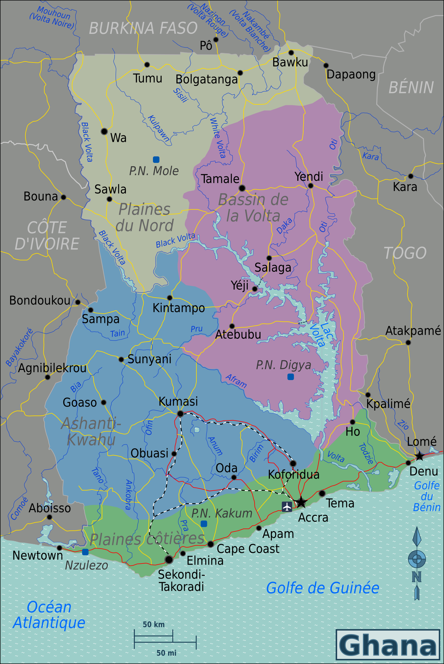
| Description | Map of Ghana for use on Wikivoyage, French version |
| Date | |
| Source | Own work based on Perry-Castañeda Library Map Collection Ghana Maps |
| Author | Burmesedays, French translation by Joelf |
| Other versions |
.png)
Licensing edit
.png&action=edit§ion=2)
This file is licensed under the Creative Commons Attribution-Share Alike 3.0 Unported license.
- You are free:
- to share – to copy, distribute and transmit the work
- to remix – to adapt the work
- Under the following conditions:
- attribution – You must give appropriate credit, provide a link to the license, and indicate if changes were made. You may do so in any reasonable manner, but not in any way that suggests the licensor endorses you or your use.
- share alike – If you remix, transform, or build upon the material, you must distribute your contributions under the same or compatible license as the original.
Original upload log edit
.png&action=edit§ion=3)
| This file was imported from Wikivoyage WTS. |
The original description page was here. All following user names refer to wts.wikivoyage-old.
.png)
- 2012-03-05 00:50 (WT-shared) Joelf[dead link] 1495×2233 (1107058 bytes) {{Imagecredit|credit=[[user:burmesedays]], [http://www.lib.utexas.edu/maps/Ghana.html Perry-Castañeda Library Map Collection Ghana Maps]|ca (Import from wikitravel.org/shared)
File history
Click on a date/time to view the file as it appeared at that time.
| Date/Time | Thumbnail | Dimensions | User | Comment | |
|---|---|---|---|---|---|
| current | 23:50, 17 November 2012 | | 1,495 × 2,233 (1.06 MB) | MGA73bot2 (talk | contribs) | {{BotMoveToCommons|wts.oldwikivoyage|year={{subst:CURRENTYEAR}}|month={{subst:CURRENTMONTHNAME}}|day={{subst:CURRENTDAY}}}} == {{int:filedesc}} == {{Information |description=Map of Ghana. PNG French version, Ghana * Map of: Ghana¤ |date=February 2nd 2... |
You cannot overwrite this file.
File usage on Commons
There are no pages that use this file.
File usage on other wikis
The following other wikis use this file:
- Usage on fr.wikivoyage.org
.png&oldid=784021180)