File:Gili Islands Region map.png

Size of this preview: 800 × 455 pixels. Other resolutions: 320 × 182 pixels | 640 × 364 pixels | 1,024 × 582 pixels | 1,280 × 727 pixels | 3,008 × 1,709 pixels.
Original file (3,008 × 1,709 pixels, file size: 701 KB, MIME type: image/png)
Captions
Captions
Add a one-line explanation of what this file represents

|
This file was moved to Wikimedia Commons from wts.oldwikivoyage using a bot script. All source information is still present. It requires review. Additionally, there may be errors in any or all of the information fields; information on this file should not be considered reliable and the file should not be used until it has been reviewed and any needed corrections have been made. Once the review has been completed, this template should be removed. For details about this file, see below. Check now! |
Summary
edit
| Description |
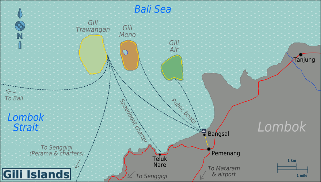
English: Map of the Gili Islands region, Lombok. SVG, Lombok
|
| Date | |
| Source | :image:Gili_Islands_Region_map.svg |
| Author | User:(WT-shared) Burmesedays,OpenStreetMap |
Licensing
edit
This file is licensed under the Creative Commons Attribution-Share Alike 3.0 Unported license.
- You are free:
- to share – to copy, distribute and transmit the work
- to remix – to adapt the work
- Under the following conditions:
- attribution – You must give appropriate credit, provide a link to the license, and indicate if changes were made. You may do so in any reasonable manner, but not in any way that suggests the licensor endorses you or your use.
- share alike – If you remix, transform, or build upon the material, you must distribute your contributions under the same or compatible license as the original.
Original upload log
edit
| This file was imported from Wikivoyage WTS. |
The original description page was here. All following user names refer to wts.wikivoyage-old.
- 2010-02-24 08:20 (WT-shared) Burmesedays[dead link] 3008×1712 (637155 bytes) {{Imagecredit|credit=[[User:Burmesedays]],[http://openstreetmap.org OpenStreetMap]|captureDate=24th February 2010|location=Lombok|source=[[: (Import from wikitravel.org/shared)
- 2010-02-24 12:09 (WT-shared) Burmesedays[dead link] 3008×1709 (714883 bytes) added more boat routes (Import from wikitravel.org/shared)
- 2010-02-25 09:12 (WT-shared) Burmesedays[dead link] 3008×1709 (718047 bytes) corrected Senggigi boat route label (Import from wikitravel.org/shared)
File history
Click on a date/time to view the file as it appeared at that time.
| Date/Time | Thumbnail | Dimensions | User | Comment | |
|---|---|---|---|---|---|
| current | 03:33, 13 December 2012 | | 3,008 × 1,709 (701 KB) | OgreBot (talk | contribs) | (BOT): Reverting to most recent version before archival |
| 03:33, 13 December 2012 |  | 3,008 × 1,709 (698 KB) | OgreBot (talk | contribs) | (BOT): Uploading old version of file from wts.wikivoyage; originally uploaded on 2010-02-24 12:09:04 by (WT-shared) Burmesedays | |
| 03:33, 13 December 2012 |  | 3,008 × 1,712 (622 KB) | OgreBot (talk | contribs) | (BOT): Uploading old version of file from wts.wikivoyage; originally uploaded on 2010-02-24 08:20:38 by (WT-shared) Burmesedays | |
| 23:51, 17 November 2012 |  | 3,008 × 1,709 (701 KB) | MGA73bot2 (talk | contribs) | {{BotMoveToCommons|wts.oldwikivoyage|year={{subst:CURRENTYEAR}}|month={{subst:CURRENTMONTHNAME}}|day={{subst:CURRENTDAY}}}} == {{int:filedesc}} == {{Information |description=Map of the Gili Islands region, Lombok. SVG, Lombok * Map of: Lombok¤ |date=2... |
You cannot overwrite this file.
File usage on Commons
There are no pages that use this file.
File usage on other wikis
The following other wikis use this file:
- Usage on de.wikivoyage.org
- Usage on en.wikipedia.org
- Usage on en.wikivoyage.org
- Usage on fr.wikivoyage.org
- Usage on incubator.wikimedia.org
- Usage on it.wikivoyage.org
- Usage on ko.wikipedia.org
- Usage on ml.wikipedia.org
- Usage on nl.wikipedia.org
- Usage on nl.wikivoyage.org
- Usage on pt.wikipedia.org
- Usage on simple.wikipedia.org