File:Ginir, Bale, Etiópia.jpg

Size of this preview: 800 × 450 pixels. Other resolutions: 320 × 180 pixels | 640 × 360 pixels | 1,024 × 576 pixels | 1,280 × 720 pixels | 2,560 × 1,440 pixels | 4,080 × 2,295 pixels.
Original file (4,080 × 2,295 pixels, file size: 6.47 MB, MIME type: image/jpeg)
Captions
Captions
Add a one-line explanation of what this file represents
Summary
edit
| Description |
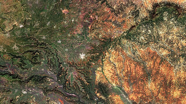
Português: Ginir, Bale, Etiópia. Áreas urbanas em salpicado branco. Padrão quadriculado, em verde, roxo e marrom, são lotes agrícolas, principalmente khat , café, trigo, frutas e legumes. Em verde escuro, savana arborizada, equivalente ao nosso cerradão / Ginir, Bale, Ethiopia. Urban areas appear in whiteish saltpepper. Checkered pattern, in green, purple and brown, are agricultural plots, mostly khat , coffee, wheat, fruits and vegetables. Wooded savanna appears in dark green.
Imagem / Image CBERS4 MUX Ginir, Bale/Etiópia. Coordenadas do centro da imagem / Image center: 7°08'13.9"N 40°32'17.0"E Data / Date: 02-12-2019 / 2019-02-12 RGB765 (cor verdadeira / true color) Cena / Scene: 071 / 092 Autor / Author: Oton Barros (DSR/OBT/INPE) Imagem em HD / HD Image Visite-nos em www.dsr.inpe.br |
| Date | |
| Source | https://www.flickr.com/photos/153282474@N02/49163947447/ |
| Author | Coordenação-Geral de Observação da Terra/INPE |
Licensing
edit
This file is licensed under the Creative Commons Attribution-Share Alike 2.0 Generic license.
- You are free:
- to share – to copy, distribute and transmit the work
- to remix – to adapt the work
- Under the following conditions:
- attribution – You must give appropriate credit, provide a link to the license, and indicate if changes were made. You may do so in any reasonable manner, but not in any way that suggests the licensor endorses you or your use.
- share alike – If you remix, transform, or build upon the material, you must distribute your contributions under the same or compatible license as the original.
| This image was originally posted to Flickr by Coordenação-Geral de Observação da Terra/INPE at https://flickr.com/photos/153282474@N02/49163947447. It was reviewed on 9 April 2020 by FlickreviewR 2 and was confirmed to be licensed under the terms of the cc-by-sa-2.0. |
File history
Click on a date/time to view the file as it appeared at that time.
| Date/Time | Thumbnail | Dimensions | User | Comment | |
|---|---|---|---|---|---|
| current | 10:12, 9 April 2020 | | 4,080 × 2,295 (6.47 MB) | Jo-Jo Eumerus (talk | contribs) | Uploaded a work by Coordenação-Geral de Observação da Terra/INPE from https://www.flickr.com/photos/153282474@N02/49163947447/ with UploadWizard |
You cannot overwrite this file.
File usage on Commons
The following 2 pages use this file:
- ኢትዮጵያ
- File:Ginir, Bale Etiópia (49163947447).jpg (file redirect)
.jpg&redirect=no)