File:Ginza-townmap-kyobashiward.png

Size of this preview: 500 × 600 pixels. Other resolutions: 200 × 240 pixels | 400 × 480 pixels | 640 × 768 pixels | 853 × 1,024 pixels | 1,500 × 1,800 pixels.
Original file (1,500 × 1,800 pixels, file size: 68 KB, MIME type: image/png)
Captions
Captions
Add a one-line explanation of what this file represents
Summary
edit
| Description |
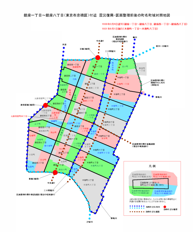
English: Ginza map, district of Chūō Ward, Tokyo.
|
| Date | |
| Source | Own work by the original uploader |
| Author | Beagle ja.wikipedia user |
Licensing
edit
| This file is licensed under the Creative Commons Attribution-Share Alike 3.0 Unported license. Subject to disclaimers. | ||
| ||
| This licensing tag was added to this file as part of the GFDL licensing update. |

|
Permission is granted to copy, distribute and/or modify this document under the terms of the GNU Free Documentation License, Version 1.2 or any later version published by the Free Software Foundation; with no Invariant Sections, no Front-Cover Texts, and no Back-Cover Texts. A copy of the license is included in the section entitled GNU Free Documentation License. Subject to disclaimers. |
Original upload log
edit
| This file was moved from Japanese Wikipedia.
See below for original file information. | ||||||||||||||||||||||||||||
| ||||||||||||||||||||||||||||
|
| ||||||||||||||||||||||||||||
File history
Click on a date/time to view the file as it appeared at that time.
| Date/Time | Thumbnail | Dimensions | User | Comment | |
|---|---|---|---|---|---|
| current | 05:04, 23 November 2006 | | 1,500 × 1,800 (68 KB) | Kimbrasil (talk | contribs) | {{GFDL}} * 東京市京橋区の震災復興における区画整理前後の町名町域対照地図 ** 掲載範囲:銀座一丁目~銀座八丁目とその周辺 ** 区画整理により消� |
| 13:33, 17 August 2006 |  | 1,500 × 1,800 (68 KB) | Beagle (talk | contribs) | {{GFDL}} * 東京市京橋区の震災復興における区画整理前後の町名町域対照地図 * 画像作成者は提供者と同じです |
You cannot overwrite this file.
File usage on Commons
The following page uses this file:
- File:Ginza-townmap2@kyobashiward.png (file redirect)
File usage on other wikis
The following other wikis use this file: