File:Glacier-capped Mountains in Tibet.jpg

Size of this preview: 480 × 599 pixels. Other resolutions: 192 × 240 pixels | 385 × 480 pixels | 615 × 768 pixels | 821 × 1,024 pixels | 1,641 × 2,048 pixels | 3,849 × 4,803 pixels.
Original file (3,849 × 4,803 pixels, file size: 2.28 MB, MIME type: image/jpeg)
Captions
Captions
Add a one-line explanation of what this file represents
Summary edit
| Description |
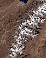
English: Image showing part of a glacier-capped mountain chain about 110 kilometres west-north-west of the Tibetan city of Lhasa. In this false-colour image, snow-free ground appears reddish-brown, snow and ice appear white, and water varies in colour from navy to aquamarine. Because the Sun’s angle is low in this wintertime shot, the mountain ridges cast long shadows toward the north. The large, nearly black area spread across the centre of the image is a shadow. The network of jewel-toned lakes in the upper left quadrant of the image likely originates from a small glacier obscured by the shade. Other lake-producing glaciers, however, sit in the sunshine, visible in the upper right and lower left quadrants of the image. Many glaciers are muddied by dirt and rocks they have ground off surrounding terrain. Besides two deep blue lakes, smaller water bodies the colour of aquamarine fringe the glaciers and pool downstream of the larger lakes. Like other water bodies, glacial lakes can vary in colour depending on water depth, sediment, or both. Glacier-fed lakes are often brightly coloured because of glacial flour—fine sediments that come from the powerful grinding action of glaciers on underlying rocks. Image captured by the Advanced Spaceborne Thermal Emission and Reflection Radiometer (ASTER) on NASA’s Terra satellite. |
| Date | |
| Source | NASA Earth Observatory |
| Author | Jesse Allen |
| Other versions |
|
Licensing edit
| This file is in the public domain in the United States because it was solely created by NASA. NASA copyright policy states that "NASA material is not protected by copyright unless noted". (See Template:PD-USGov, NASA copyright policy page or JPL Image Use Policy.) | ||
 |
Warnings:
|
File history
Click on a date/time to view the file as it appeared at that time.
| Date/Time | Thumbnail | Dimensions | User | Comment | |
|---|---|---|---|---|---|
| current | 15:01, 24 April 2010 | | 3,849 × 4,803 (2.28 MB) | Originalwana (talk | contribs) | {{Information |Description={{en|1=Image showing part of a glacier-capped mountain chain about 110 kilometres west-north-west of the Tibetan city of Lhasa. In this false-colour image, snow-free ground appears [[:Catego |
You cannot overwrite this file.
File usage on Commons
The following page uses this file:
File usage on other wikis
The following other wikis use this file:
- Usage on ca.wikipedia.org
- Usage on en.wikipedia.org
- Usage on sl.wikipedia.org
- Usage on www.wikidata.org