File:Glen Echo Park Map (500ebd65-092e-8de9-f97d-3a7bbbafefe3).jpg

Original file (1,200 × 815 pixels, file size: 201 KB, MIME type: image/jpeg)
Captions
Captions
Summary
edit| English: Glen Echo Park Map | ||||
|---|---|---|---|---|
| Photographer |
English: NPS |
|||
| Title |
English: Glen Echo Park Map |
|||
| Publisher |
English: U.S. National Park Service |
|||
| Description |
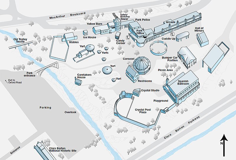
English: A map of the amusement park identifies buildings, structures, and some other features. Glen Echo Park-Clara Barton House. A site plan shows features and arrangement of the cultural landscape, ca. 1997. The unmarked structure at the right once housed the park's "Kiddieland" attraction, but it was demolished ca. 2002. Otherwise, the layout is unchanged. The first amusement park structures were erected on the site in 1899, and Glen Echo Park operated in this capacity until 1968. Many rides have been removed since then, impacting the form of the landscape; overall, continuity outweighs the changes.
|
|||
| Depicted place |
English: 38.96589, -77.13872 |
|||
| Date | Taken on 28 February 2011 | |||
| Accession number | ||||
| Source |
English: NPGallery |
|||
| Permission (Reusing this file) |
|
|||
| Other versions |
|
|||
| NPS Unit Code | NPS | |||

.jpg&action=edit§ion=1)
File history
Click on a date/time to view the file as it appeared at that time.
| Date/Time | Thumbnail | Dimensions | User | Comment | |
|---|---|---|---|---|---|
| current | 08:01, 12 May 2024 | | 1,200 × 815 (201 KB) | BMacZeroBot (talk | contribs) | Batch upload (Commons:Batch uploading/NPGallery) |
You cannot overwrite this file.
File usage on Commons
The following 3 pages use this file:
.jpg)
.jpg&oldid=876829132)