File:Goes 1749 Hattinga'.jpg

Size of this preview: 800 × 400 pixels. Other resolutions: 320 × 160 pixels | 640 × 320 pixels | 1,024 × 512 pixels | 1,280 × 640 pixels | 3,071 × 1,535 pixels.
Original file (3,071 × 1,535 pixels, file size: 900 KB, MIME type: image/jpeg)
Captions
Captions
Add a one-line explanation of what this file represents
Summary edit
| Description |
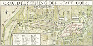
Nederlands: 18e eeuwse plattegrond van Goes, Zuid-Beveland, Zeeland, Nederland |
| Date | |
| Source | In 4 delen ingescande kaart uit eigen collectie |
| Author | Hattinga |
Goes, Zuid-Beveland, Zeeland, Nederland
Licensing edit
|
This work is in the public domain in its country of origin and other countries and areas where the copyright term is the author's life plus 100 years or fewer. | |
| This file has been identified as being free of known restrictions under copyright law, including all related and neighboring rights. | |
File history
Click on a date/time to view the file as it appeared at that time.
| Date/Time | Thumbnail | Dimensions | User | Comment | |
|---|---|---|---|---|---|
| current | 09:18, 21 June 2011 | | 3,071 × 1,535 (900 KB) | Joopr (talk | contribs) | {{Information |Description ={{nl|1=18e eeuwse plattegrond van Goes, Zuid-Beveland, Zeeland, Nederland}} |Source =In 4 delen ingescande kaart uit eigen collectie |Author =Hattinga |Date =1749 |Permission = |other_versions = |
You cannot overwrite this file.
File usage on Commons
There are no pages that use this file.
File usage on other wikis
The following other wikis use this file: