File:GolanBordersHE.svg

Size of this PNG preview of this SVG file: 374 × 599 pixels. Other resolutions: 150 × 240 pixels | 300 × 480 pixels | 479 × 768 pixels | 639 × 1,024 pixels | 1,279 × 2,048 pixels | 534 × 855 pixels.
Original file (SVG file, nominally 534 × 855 pixels, file size: 73 KB)
Captions
Captions
Add a one-line explanation of what this file represents
| Description |
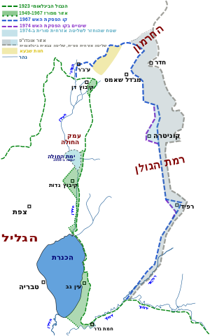
English: A map in Hebrew of current and historical borders and ceasefire lines in the Golan Heights region (from 1923)
עברית: מפה המתארת את הגבולות וקווי הפסקת האש ברמת הגולן בעבר ובהווה (מאז 1923) |
||
| Date | |||
| Source | Own work | ||
| Author | Drork | ||
| Permission (Reusing this file) |
|
File history
Click on a date/time to view the file as it appeared at that time.
| Date/Time | Thumbnail | Dimensions | User | Comment | |
|---|---|---|---|---|---|
| current | 04:06, 29 August 2009 | | 534 × 855 (73 KB) | Ori~ (talk | contribs) | edit |
| 03:57, 29 August 2009 |  | 534 × 855 (286 KB) | Ori~ (talk | contribs) | ed | |
| 09:54, 5 September 2008 |  | 534 × 855 (286 KB) | Drork (talk | contribs) | {{Information |Description={{en|1=A map in Hebrew of current and historical borders and ceasefire lines in the Golan Heights region (from 1923)}} {{he|1=מפה המתארת את הגבולות וקווי הפסקת האש ברמת הגולן בעבר וב |
You cannot overwrite this file.
File usage on Commons
The following page uses this file:
File usage on other wikis
The following other wikis use this file:
- Usage on ar.wikipedia.org
- Usage on arz.wikipedia.org
- Usage on ceb.wikipedia.org
- Usage on cs.wikipedia.org
- Usage on he.wikipedia.org
- רמת הגולן
- ירמוך
- חוק רמת הגולן
- הסכם הפרדת הכוחות בין ישראל לסוריה
- הקו הסגול
- יחסי ישראל–סוריה
- אונדו"ף
- שיחת משתמש:הגמל התימני/ארכיון 9
- נחל רוקד
- מלחמת ההתשה במובלעת הסורית
- חדר (כפר)
- מעמדה המשפטי והבין-לאומי של רמת הגולן
- ויקיפדיה:סדנה לגרפיקה/ארכיון 46
- שיחה:רמת הגולן/ארכיון 1
- גבול ישראל–סוריה
- ויקיפדיה:הכה את המומחה/ארכיון327
- Usage on nn.wikipedia.org
- Usage on pl.wikipedia.org
- Usage on ro.wikipedia.org
- Usage on ru.wikipedia.org
- Usage on www.wikidata.org