File:Golan Trail en.png
Size of this preview: 314 × 599 pixels. Other resolutions: 126 × 240 pixels | 448 × 855 pixels.
Original file (448 × 855 pixels, file size: 104 KB, MIME type: image/png)
Captions
Captions
Add a one-line explanation of what this file represents
Summary
edit
| Description |
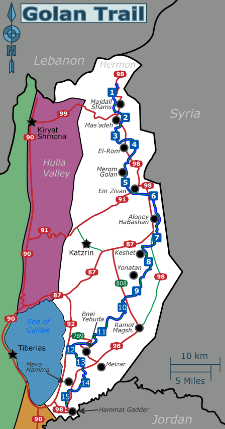
English: Schematic map of the Golan Heights showing main roads, several settlements and the Golan Trail (marked with a dotted green line) with trail-section numbers. |
| Date | |
| Source | Own work |
| Author | Tamuz |
| Other versions | SVG source: File:Golan Trail en he.svg |
Image map you can use for clicking the numbered buttons:
<imagemap>
Image:Golan Trail en.png|thumb|448px|The Golan Trail is marked by a green dotted line. Click on a section number to visit it.

rect 213 173 231 192 [[#1]]
rect 240 224 258 242 [[#2]]
rect 219 260 238 280 [[#3]]
rect 258 278 276 297 [[#4]]
rect 241 354 259 372 [[#5]]
rect 294 380 315 399 [[#6]]
rect 304 464 321 483 [[#7]]
rect 287 512 305 531 [[#8]]
rect 264 571 281 589 [[#9]]
rect 235 604 252 622 [[#10]]
rect 195 653 212 671 [[#11]]
rect 132 689 150 706 [[#12]]
rect 152 713 170 731 [[#13]]
rect 162 755 179 772 [[#14]]
rect 122 782 140 799 [[#15]]

desc top-right
</imagemap>
Licensing
edit
I, the copyright holder of this work, hereby publish it under the following license:
| This file is made available under the Creative Commons CC0 1.0 Universal Public Domain Dedication. | |
| The person who associated a work with this deed has dedicated the work to the public domain by waiving all of their rights to the work worldwide under copyright law, including all related and neighboring rights, to the extent allowed by law. You can copy, modify, distribute and perform the work, even for commercial purposes, all without asking permission.
|
File history
Click on a date/time to view the file as it appeared at that time.
| Date/Time | Thumbnail | Dimensions | User | Comment | |
|---|---|---|---|---|---|
| current | 13:41, 22 November 2013 | | 448 × 855 (104 KB) | Tamuz (talk | contribs) | Made the trail-mark more prominent in the map. |
| 23:33, 26 August 2013 |  | 448 × 855 (99 KB) | Tamuz (talk | contribs) | User created page with UploadWizard |
You cannot overwrite this file.
File usage on Commons
There are no pages that use this file.
File usage on other wikis
The following other wikis use this file:
- Usage on en.wikivoyage.org
- Usage on fr.wikipedia.org