File:Gorée 1745-47.jpg
No higher resolution available.
Gorée_1745-47.jpg (723 × 309 pixels, file size: 66 KB, MIME type: image/jpeg)
Captions
Captions
Add a one-line explanation of what this file represents
Summary
edit
| Description |
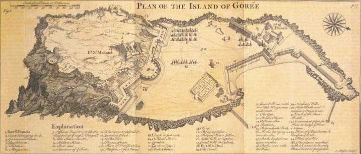
English: Plan of the Island of Gorée; [Fort St. Michael; Fort St. Francis]
Français : Plan de l'île de Gorée (Fort Saint-Michel ; Fort Saint-François) |
||
| Date | between 1745 and 1747 | ||
| Source | New York Public Library [1] from A new general collection of voyages and travels; consisting of the most esteemed relations, which have been hitherto published in any language; comprehending everything remarkable in its kind, in Europe, Asia, Africa, and America | ||
| Author | Green, John, fl. 1730-1753 -- Compiler ; Astley, Thomas -- Author | ||
| Permission (Reusing this file) |
|
Licensing
edit
|
This work is in the public domain in its country of origin and other countries and areas where the copyright term is the author's life plus 100 years or fewer. | |
| This file has been identified as being free of known restrictions under copyright law, including all related and neighboring rights. | |
File history
Click on a date/time to view the file as it appeared at that time.
| Date/Time | Thumbnail | Dimensions | User | Comment | |
|---|---|---|---|---|---|
| current | 12:15, 26 March 2009 | | 723 × 309 (66 KB) | Ji-Elle (talk | contribs) | == Description == {{Information |Description={{en|1=Plan of the Island of Gorée; [Fort St. Michael; Fort St. Francis] }} {{fr|1=Plan de l'île de Gorée (Fort Saint-Michel ; Fort Saint-François) }} |Source=New York Public Library [http://digitalgallery |
You cannot overwrite this file.
File usage on Commons
The following page uses this file: