File:Gorbals - geograph-5057196-by-Thomas-Nugent.jpg
No higher resolution available.
Gorbals_-_geograph-5057196-by-Thomas-Nugent.jpg (640 × 480 pixels, file size: 150 KB, MIME type: image/jpeg)
Captions
Captions
Add a one-line explanation of what this file represents
Summary
edit
| Description |
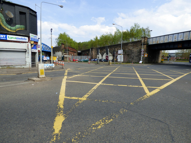
English: Site of two former railway stations Gorbals Junction (no longer a junction) stood where the two viaducts meet in a V shape (as seen in the tree line). Main Street station on the City Union line was on the left, Gorbals station on the Glasgow, Barrhead and Neilston Direct Railway line was on the right (the steps up to the site of the station can be seen behind the grey fence). |
| Date | |
| Source | From geograph.org.uk |
| Author | Thomas Nugent |
| Permission (Reusing this file) |
Creative Commons Attribution Share-alike license 2.0 |
| Attribution (required by the license) | Thomas Nugent / Site of two former railway stations / |
| Camera location | | View this and other nearby images on: OpenStreetMap |
|---|
_heading:67.00&language=en)
| Object location | | View this and other nearby images on: OpenStreetMap |
|---|
_heading:67.00&language=en)
Licensing
edit

|
This image was taken from the Geograph project collection. See this photograph's page on the Geograph website for the photographer's contact details. The copyright on this image is owned by Thomas Nugent and is licensed for reuse under the Creative Commons Attribution-ShareAlike 2.0 license.
|
This file is licensed under the Creative Commons Attribution-Share Alike 2.0 Generic license.
Attribution: Thomas Nugent
- You are free:
- to share – to copy, distribute and transmit the work
- to remix – to adapt the work
- Under the following conditions:
- attribution – You must give appropriate credit, provide a link to the license, and indicate if changes were made. You may do so in any reasonable manner, but not in any way that suggests the licensor endorses you or your use.
- share alike – If you remix, transform, or build upon the material, you must distribute your contributions under the same or compatible license as the original.
File history
Click on a date/time to view the file as it appeared at that time.
| Date/Time | Thumbnail | Dimensions | User | Comment | |
|---|---|---|---|---|---|
| current | 20:52, 25 November 2020 | | 640 × 480 (150 KB) | Lamberhurst (talk | contribs) | == {{int:filedesc}} == {{Information |Description={{en|1=<b>Site of two former railway stations</b><br>Gorbals Junction (no longer a junction) stood where the two viaducts meet in a V shape (as seen in the tree line). Main Street station on the City Union line was on the left, Gorbals station on the Glasgow, Barrhead and Neilston Direct Railway line was on the right (the steps up to the site of the station can be seen behind the grey fence).}} |Source=From [https://www.geograph.org.uk/photo/5... |
You cannot overwrite this file.
File usage on Commons
The following page uses this file: