File:Gotthardbahn ohne Basistunnel.png
Size of this preview: 258 × 598 pixels. Other resolutions: 103 × 240 pixels | 207 × 480 pixels | 331 × 768 pixels | 441 × 1,024 pixels | 883 × 2,048 pixels | 2,702 × 6,264 pixels.
Original file (2,702 × 6,264 pixels, file size: 12.64 MB, MIME type: image/png)
Captions
Captions
Add a one-line explanation of what this file represents
Summary edit
| Description |
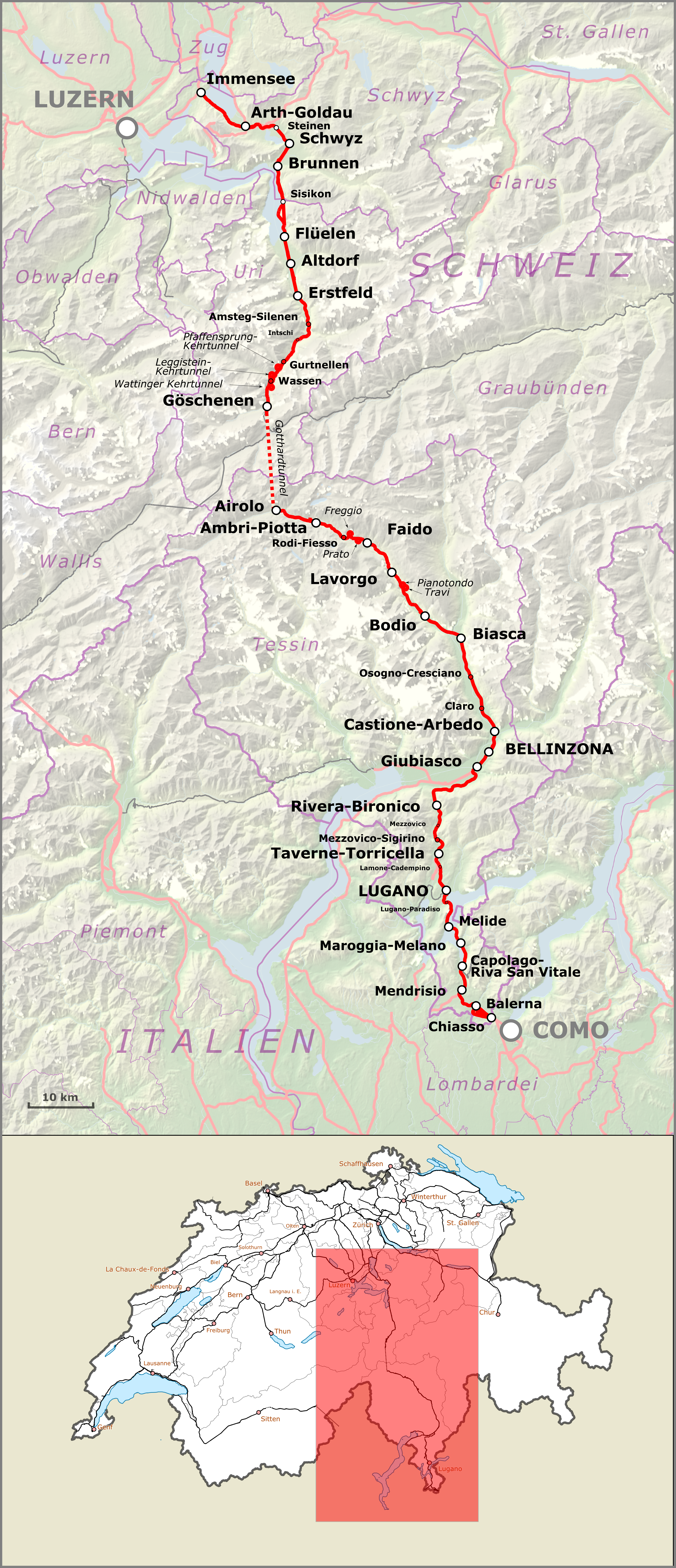
Deutsch: Karte der Gotthardbahn in der Schweiz ohne Basistunnel.
Alemannisch: Charte vo de Gotthardbahn ohni NEAT
Français : Carte de la Ligne du Gothard sans NEAT
Nederlands: Kaart van de Spoorlijn Immensee - Chiasso |
| Date | |
| Source |
Map was created using Open Street Map Data Map was created using:
|
| Author |
|
| Permission (Reusing this file) |
Map data (c) OpenStreetMap (and) contributors, CC-BY-SA |
| Other versions |
Licensing edit
This file is licensed under the Creative Commons Attribution-Share Alike 2.0 Generic license.
- You are free:
- to share – to copy, distribute and transmit the work
- to remix – to adapt the work
- Under the following conditions:
- attribution – You must give appropriate credit, provide a link to the license, and indicate if changes were made. You may do so in any reasonable manner, but not in any way that suggests the licensor endorses you or your use.
- share alike – If you remix, transform, or build upon the material, you must distribute your contributions under the same or compatible license as the original.
| This work is licensed under the Open Database License (summary). |
File history
Click on a date/time to view the file as it appeared at that time.
| Date/Time | Thumbnail | Dimensions | User | Comment | |
|---|---|---|---|---|---|
| current | 15:14, 2 June 2016 | | 2,702 × 6,264 (12.64 MB) | Pechristener (talk | contribs) | Gotthardtunnel angeschrieben |
| 18:42, 22 September 2015 |  | 2,702 × 6,264 (12.63 MB) | Pechristener (talk | contribs) | == {{int:filedesc}} == {{Information |Description = {{de|1=Karte der de:Gotthardbahn in der Schweiz ohne Basistunnel.}} {{als|1=Charte vo de Gotthardbahn ohni NEAT}} {{fr|1=Carte de la [[:fr:Ligne_du_Gothard|Ligne du Gotha... |
You cannot overwrite this file.
File usage on Commons
The following 8 pages use this file:
- User:Chumwa/OgreBot/Potential transport maps/2016 June 1-10
- User:Chumwa/OgreBot/Public transport information/2015 September 21-30
- User:Chumwa/OgreBot/Public transport information/2016 June 1-10
- User:Chumwa/OgreBot/Transport Maps/2015 September 21-30
- User:Chumwa/OgreBot/Transport Maps/2016 June 1-10
- User:Chumwa/OgreBot/Travel and communication maps/2016 June 1-10
- File:Gotthardbahn map.png
- Category:Gotthardbahn
File usage on other wikis
The following other wikis use this file:
- Usage on lmo.wikipedia.org
- Usage on ru.wikipedia.org
- Usage on www.wikidata.org