File:Gps-abweichungen-wald.png

Size of this preview: 750 × 600 pixels. Other resolutions: 300 × 240 pixels | 600 × 480 pixels | 960 × 768 pixels | 1,280 × 1,024 pixels.
Original file (1,280 × 1,024 pixels, file size: 156 KB, MIME type: image/png)
Captions
Captions
Add a one-line explanation of what this file represents
Summary
edit
| Description |
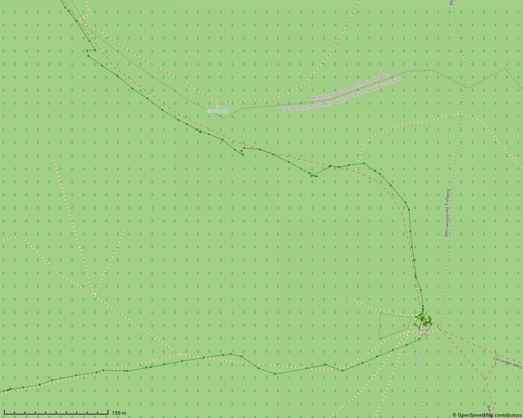
English: GPS deviation of a good receiver (Garmin Montana 600) on walking through a forest. The green track was recorded while the walker stuck to the paths given in the map.
Deutsch: GPS-Abweichungen eines guten Empfängers (Garmin Montana 600) im Wald. Der grüne Track wurde aufgezeichnet, während nur auf den eingezeichneten Wegen gewandert wurde. |
| Date | |
| Source | Own work |
| Author | Kreuzschnabel |
| Description |
This map was created from OpenStreetMap project data, collected by the community. This map may be incomplete, and may contain errors. Don't rely solely on it for navigation. |
|||
| Date | (see file history) | |||
| Source | openstreetmap.org | |||
| Creator |
OpenStreetMap contributors |
|||
| Permission (Reusing this file) |
OpenStreetMap data is available under the Open Database License (details). Map tiles are licensed under the Creative Commons Attribution-ShareAlike 2.0 license (CC-BY-SA 2.0).
This file is licensed under the Creative Commons Attribution-Share Alike 2.0 Generic license.
|
|||
| Georeferencing | If inappropriate please set warp_status = skip to hide. |
Licensing
edit
I, the copyright holder of this work, hereby publish it under the following license:
This file is licensed under the Creative Commons Attribution-Share Alike 3.0 Unported license.
- You are free:
- to share – to copy, distribute and transmit the work
- to remix – to adapt the work
- Under the following conditions:
- attribution – You must give appropriate credit, provide a link to the license, and indicate if changes were made. You may do so in any reasonable manner, but not in any way that suggests the licensor endorses you or your use.
- share alike – If you remix, transform, or build upon the material, you must distribute your contributions under the same or compatible license as the original.
File history
Click on a date/time to view the file as it appeared at that time.
| Date/Time | Thumbnail | Dimensions | User | Comment | |
|---|---|---|---|---|---|
| current | 19:55, 10 May 2015 | | 1,280 × 1,024 (156 KB) | Kreuzschnabel (talk | contribs) | {{Information |Description ={{en|1=GPS deviation of a good receiver (Garmin Montana 600) on walking through a forest. The walker stuck to the paths given in the map. }} {{de|1=GPS-Abweichungen eines guten Empfängers (Garmin Montana 600) im Wald. Es... |
You cannot overwrite this file.
File usage on Commons
There are no pages that use this file.