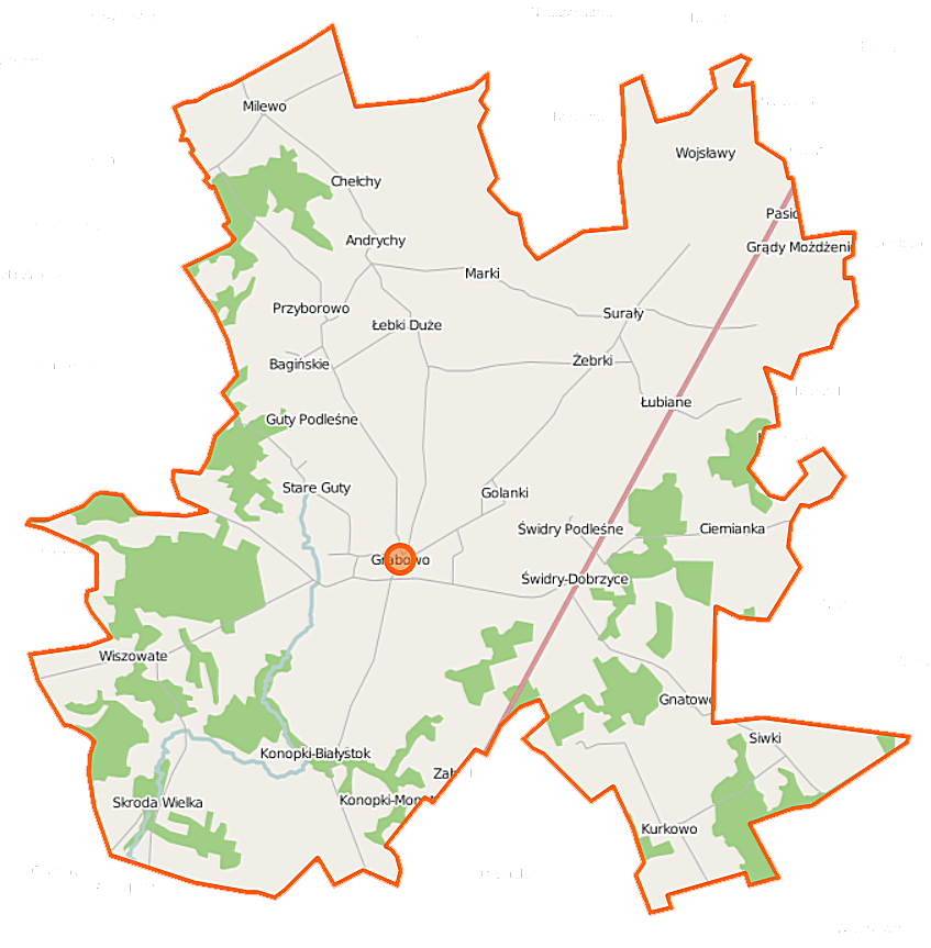
File:Grabowo (gmina) location map.png
Size of this preview: 588 × 599 pixels. Other resolutions: 236 × 240 pixels | 471 × 480 pixels | 847 × 863 pixels.
Original file (847 × 863 pixels, file size: 167 KB, MIME type: image/png)
Captions
Captions
Add a one-line explanation of what this file represents
| Description |
Polski: Mapa gminy Grabowo, Polska
English: Map of Gmina Grabowo, Poland |
|||||||||
| Date | ||||||||||
| Source | You may find a page on the OpenStreetMap wiki page for Grabowo (gmina) | |||||||||
| Creator |
OpenStreetMap contributors OpenStreetMap contributors |
|||||||||
| Permission (Reusing this file) |
OpenStreetMap data is available under the Open Database License (details). Map tiles are licensed under the Creative Commons Attribution-ShareAlike 2.0 license (CC-BY-SA 2.0).
This file is licensed under the Creative Commons Attribution-Share Alike 2.0 Generic license.
|
|||||||||
| Geotemporal data | ||||||||||
| Bounding box |
|
|||||||||
| Georeferencing | If inappropriate please set warp_status = skip to hide. | |||||||||
File history
Click on a date/time to view the file as it appeared at that time.
| Date/Time | Thumbnail | Dimensions | User | Comment | |
|---|---|---|---|---|---|
| current | 09:49, 16 September 2014 | | 847 × 863 (167 KB) | VanWiel (talk | contribs) | |
| 07:47, 13 June 2014 |  | 847 × 863 (168 KB) | VanWiel (talk | contribs) | {{OpenStreetMap | name = Grabowo (gmina) | location = Grabowo (gmina) | description = {{pl|Mapa gminy Grabowo, Polska}} {{en|Map of Gmina Grabowo, Poland}} | top = 53.5485 | left = 22.0527 | right... |
You cannot overwrite this file.
File usage on Commons
There are no pages that use this file.
File usage on other wikis
The following other wikis use this file:
- Usage on be.wikipedia.org
- Usage on pl.wikipedia.org
- Grabowo (gmina)
- Andrychy
- Bagińskie
- Ciemianka
- Golanki (województwo podlaskie)
- Grabowskie
- Guty Podleśne
- Grądy-Michały
- Grądy-Możdżenie
- Kurkowo (województwo podlaskie)
- Konopki-Białystok
- Konopki-Monety
- Kownacin
- Łebki Duże
- Łebki Małe
- Łubiane
- Milewo-Gałązki
- Pasichy
- Rosochate (województwo podlaskie)
- Siwki (wieś)
- Skroda Wielka
- Surały
- Stawiane
- Świdry-Dobrzyce
- Świdry Podleśne
- Wiszowate
- Wojsławy
- Żebrki
- Chełchy (województwo podlaskie)
- Gnatowo (województwo podlaskie)
- Marki (województwo podlaskie)
- Przyborowo (województwo podlaskie)
- Grabowo (powiat kolneński)
- Stare Guty (województwo podlaskie)
- Jadłówek
- Borzymy (powiat kolneński)
- Dąbrowa (powiat kolneński)
- Gałązki (województwo podlaskie)
- Kamińskie (województwo podlaskie)
- Parafia św. Jana Chrzciciela w Grabowie
- Sulimy (Konopki-Białystok)
- Kościół św. Jana Chrzciciela w Grabowie
- Moduł:Mapa/dane/Grabowo (gmina)
- Usage on pl.wikibooks.org
_location_map.png&oldid=519964919)