File:Gran San Miguel de Tucumán.svg

Size of this PNG preview of this SVG file: 737 × 600 pixels. Other resolutions: 295 × 240 pixels | 590 × 480 pixels | 944 × 768 pixels | 1,258 × 1,024 pixels | 2,517 × 2,048 pixels | 999 × 813 pixels.
Original file (SVG file, nominally 999 × 813 pixels, file size: 528 KB)
Captions
Captions
Add a one-line explanation of what this file represents
Summary edit
| Description |
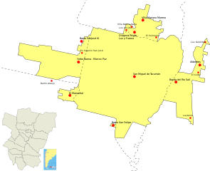
English: Map showing urban area and towns of Gran San Miguel de Tucumán (Tucumán Province, Argentina), according to 2001 Census by INDEC. Source: INDEC
Español: Mapa con el área urbana y las localdades del Gran San Miguel de Tucumán (Provincia de Tucumán, Argentina), según el Censo de 2001 del INDEC. Fuente: INDEC |
| Source | Own work |
| Author | Pertile |
Licensing edit
I, the copyright holder of this work, hereby publish it under the following licenses:

|
Permission is granted to copy, distribute and/or modify this document under the terms of the GNU Free Documentation License, Version 1.2 or any later version published by the Free Software Foundation; with no Invariant Sections, no Front-Cover Texts, and no Back-Cover Texts. A copy of the license is included in the section entitled GNU Free Documentation License. |
This file is licensed under the Creative Commons Attribution-Share Alike 4.0 International, 3.0 Unported, 2.5 Generic, 2.0 Generic and 1.0 Generic license.
- You are free:
- to share – to copy, distribute and transmit the work
- to remix – to adapt the work
- Under the following conditions:
- attribution – You must give appropriate credit, provide a link to the license, and indicate if changes were made. You may do so in any reasonable manner, but not in any way that suggests the licensor endorses you or your use.
- share alike – If you remix, transform, or build upon the material, you must distribute your contributions under the same or compatible license as the original.
You may select the license of your choice.
File history
Click on a date/time to view the file as it appeared at that time.
| Date/Time | Thumbnail | Dimensions | User | Comment | |
|---|---|---|---|---|---|
| current | 13:04, 27 April 2012 | | 999 × 813 (528 KB) | Pertile (talk | contribs) | Diagonal Norte-Luz y Fuerza, Los Pocitos, Villa Nueva Italia. Villa Mariano Moreno, El Colmenar. |
| 12:57, 27 April 2012 |  | 999 × 813 (526 KB) | Pertile (talk | contribs) | Added El Corte, Los Gutiérrez, Barrio Araujo, Ex Ingenio San José and Lastenia. | |
| 21:33, 26 July 2010 |  | 999 × 813 (927 KB) | Pertile (talk | contribs) | Just move Alderetes label, so it keeps on the frame. | |
| 21:28, 26 July 2010 |  | 999 × 813 (927 KB) | Pertile (talk | contribs) | {{Information |Description={{en|1=Map showing urban area and towns of Gran San Miguel de Tucumán (Tucumán Province, Argentina), according to 2001 Census by INDEC. Source: [http://200.51.91.231/index.php INDEC]}} {{es|1=Mapa con el área urbana y las loc |
You cannot overwrite this file.
File usage on Commons
There are no pages that use this file.
File usage on other wikis
The following other wikis use this file:
- Usage on es.wikipedia.org