File:Grand Canyon (1).jpg

Size of this preview: 800 × 533 pixels. Other resolutions: 320 × 213 pixels | 640 × 427 pixels | 1,024 × 683 pixels | 1,280 × 853 pixels | 3,000 × 2,000 pixels.
Original file (3,000 × 2,000 pixels, file size: 2.64 MB, MIME type: image/jpeg)
Captions
Captions
Add a one-line explanation of what this file represents
Summary
edit.jpg&action=edit§ion=1)
| Description |
Deutsch: Grand Canyon, Sicht vom Yavapai Point
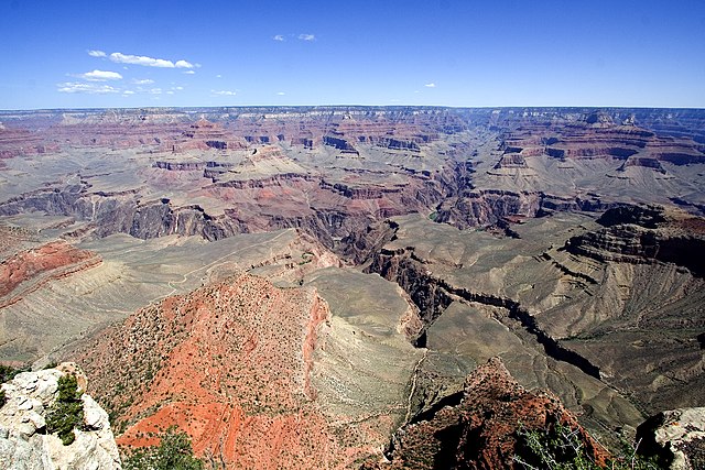
English: View from Yavapai Point. Brignt Angel Canyon, opposite Yavapai Point, (South Rim, view of Kaibab Plateau, North Rim). The thin, resistant en:Tapeats Sandstone forms the flatness in the inner canyon-(Tonto Platform), with the slope-forming units of Muav Limestone, and Bright Angel Shale accumulating upon it. The cliffs of the Redwall Limestone is one geologic layer above. (view slightly north-northwest) Isis Temple is the prominence in center. (Pipe Creek (canyon) is below on South Rim side). West of Isis Temple is Trinity Creek and its watershed canyon. Behind Isis Temple is the Phantom Creek, and watershed, with Buddha Temple and Buddha Cloister, just to the right (two points extend south to form Buddha Cloister -- Sturdevant Point, left, and Johnson Point (right over Bright Angel Canyon). (below, right, to Isis Temple) Cheops Pyramid (over whitish slopes). Isis Temple and Cheops Pyramid sit at the southwest fault block (a horst) at Bright Angel Canyon (and south wall of Phantom Creek (canyon)). The Grandview-Phantom faultline crosses, from NW to E-by-SE, (to Grandview Point-(South Rim), to turn, due-south). It intersects, here, at Granite Gorge with the Bright Angel Fault (NNE-by-SSW, approximate, north rim and south rim (up Indian Garden, Garden Creek)). The Unkar Group Horst which Isis and Cheops sit on has 3 sub-faults, as part of the horst-landform. The reddish and lavendar slopes at the promincence's base are Hakatai Shale, over Bsss Limestone. The Shinumo Quartzite forms the erosion-resistant cliff, above. (with no Tapeats Sandstone-(Tapeats Sea), the Shinumo was an island; instead, Bright Angel Shale, and Muav Limestone, above Note: Trinity Creek (watershed), left; Ninetyone Mile Creek wateshed (0.5 mi east); unnamed Wash, (drains Cheops Pyramid, on Unkar Group Horst), Wash = "Eightynine Mile Wash", and opposite outfall of Garden Creek (& Canyon, with en:Bright Angel Trail, from Maricopa Point region, South Rim); and Bright Angel Canyon (& Creek), photo right) |
| Date | 04/06 |
| Source | Own work |
| Author | tom bernard anyz; Tenji at de.wikipedia |
Licensing
edit.jpg&action=edit§ion=2)
Tenji at the German-language Wikipedia, the copyright holder of this work, hereby publishes it under the following license:

|
Permission is granted to copy, distribute and/or modify this document under the terms of the GNU Free Documentation License, Version 1.2 or any later version published by the Free Software Foundation; with no Invariant Sections, no Front-Cover Texts, and no Back-Cover Texts. A copy of the license is included in the section entitled GNU Free Documentation License. |
| This file is licensed under the Creative Commons Attribution-Share Alike 3.0 Unported license. | ||
| Attribution: Tenji | ||
| ||
| This licensing tag was added to this file as part of the GFDL licensing update. |
Original upload log
edit.jpg&action=edit§ion=3)
Transferred from de.wikipedia to Commons by Samoborac.
The original description page was here. All following user names refer to de.wikipedia.
- 2006-07-25 06:29 Tenji 3000×2000×8 (2763423 bytes) * Bildbeschreibung: grand canyon * Quelle: selbst fotografiert * Fotograf/Zeichner: tom bernard anyz * Datum: 04/06
| Annotations | This image is annotated: View the annotations at Commons |
.jpg)
[[Category:Bass Formation
File history
Click on a date/time to view the file as it appeared at that time.
| Date/Time | Thumbnail | Dimensions | User | Comment | |
|---|---|---|---|---|---|
| current | 15:23, 10 March 2008 | | 3,000 × 2,000 (2.64 MB) | File Upload Bot (Magnus Manske) (talk | contribs) | {{BotMoveToCommons|de.wikipedia}} {{Information |Description={{de|Grand canyon}} |Source=Transferred from [http://de.wikipedia.org de.wikipedia]; Transfer was stated to be made by User:Samoborac.<br/> (Original text : ''Selbst fotografiert'') |Date=0 |
You cannot overwrite this file.
File usage on Commons
The following page uses this file:
File usage on other wikis
The following other wikis use this file:
- Usage on arz.wikipedia.org
- Usage on ceb.wikipedia.org
- Usage on de.wikipedia.org
- Usage on hr.wikipedia.org
- Usage on lld.wikipedia.org
- Usage on pt.wikipedia.org
- Usage on sh.wikipedia.org
- Usage on sr.wikipedia.org
- Usage on www.wikidata.org
.jpg&oldid=632379592)