File:Grand Canyon Indians.png

Size of this preview: 511 × 600 pixels. Other resolutions: 204 × 240 pixels | 409 × 480 pixels | 654 × 768 pixels | 872 × 1,024 pixels | 1,582 × 1,857 pixels.
Original file (1,582 × 1,857 pixels, file size: 3.28 MB, MIME type: image/png)
Captions
Captions
Add a one-line explanation of what this file represents
| Description |
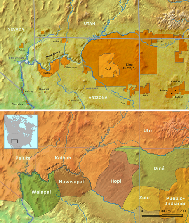
Map of Native American tribes in Arizona — located in the Grand Canyon and Northern Arizona regions.
|
||||
| Date | |||||
| Source | Own work by Nikater, submitted to the public domain. Background map courtesy of Demis, www.demis.nl | ||||
| Author | User:Nikater | ||||
| Permission (Reusing this file) |
|
File history
Click on a date/time to view the file as it appeared at that time.
| Date/Time | Thumbnail | Dimensions | User | Comment | |
|---|---|---|---|---|---|
| current | 13:23, 27 August 2015 | | 1,582 × 1,857 (3.28 MB) | RokerHRO (talk | contribs) | optipng -i0 -zc1-9 -zm1-9 -zs0-3 -f0-5 -i0 → 10.21% decrease |
| 17:13, 18 November 2007 |  | 1,582 × 1,857 (3.65 MB) | Nikater (talk | contribs) | {{Information |Description=Map of traditional Indian tribal territories and reservations in the Grand Canyon area. |Source=Own work by Nikater, submitted to the public domain. Background map courtesy of Demis, www.demis.nl |Date=18 November 2007 |Author=[ |
You cannot overwrite this file.
File usage on Commons
There are no pages that use this file.
File usage on other wikis
The following other wikis use this file:
- Usage on bg.wikipedia.org
- Usage on da.wikipedia.org
- Usage on de.wikipedia.org
- Usage on en.wikipedia.org
- Usage on eo.wikipedia.org
- Usage on fi.wikipedia.org
- Usage on he.wikipedia.org
- Usage on nl.wikipedia.org
- Usage on no.wikipedia.org