File:Grand Plateau Glacier.jpg

Size of this preview: 600 × 600 pixels. Other resolutions: 240 × 240 pixels | 480 × 480 pixels | 768 × 768 pixels | 1,024 × 1,024 pixels | 2,048 × 2,048 pixels | 2,566 × 2,566 pixels.
Original file (2,566 × 2,566 pixels, file size: 1.34 MB, MIME type: image/jpeg)
Captions
Captions
Add a one-line explanation of what this file represents
Summary
edit
| Description |
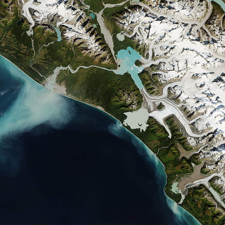
English: Glacier Bay National Park in southeast Alaska is famous for its glaciers that flow into the sea. A handful of these tidewater glaciers are accessible via boat, giving visitors a close-up view of towering ice fronts and dramatic calving events. But most of the park’s glaciers are inland, deep in the Alaskan wilderness, where the changes are more difficult to observe with human eyes.
“Glacier Bay National Park is a well-known and visited area that is showing significant ice loss,” said Christopher Shuman, a University of Maryland, Baltimore County glaciologist based at NASA’s Goddard Space Flight Center. “But all the glacier thinning and retreat, as well as increased debris-cover and dramatic landslides, haven’t been fully documented yet.” Views from above, acquired by aircraft or satellites, are helping scientists understand the extent of change across the region. The images above show the remote Grand Plateau Glacier, located about 50 kilometers west of Glacier Bay across the Fairweather Range. |
| Date | |
| Source | https://earthobservatory.nasa.gov/images/147110/grand-plateau-glacier |
| Author | NASA Earth Observatory images by Joshua Stevens, using Landsat data from the U.S. Geological Survey, topographic data from the Shuttle Radar Topography Mission (SRTM), and land cover data from the Multi-Resolution Land Characteristics (MRLC) Consortium. Story by Kathryn Hansen. |
Licensing
edit
| This file is in the public domain in the United States because it was solely created by NASA. NASA copyright policy states that "NASA material is not protected by copyright unless noted". (See Template:PD-USGov, NASA copyright policy page or JPL Image Use Policy.) | ||
 |
Warnings:
|
File history
Click on a date/time to view the file as it appeared at that time.
| Date/Time | Thumbnail | Dimensions | User | Comment | |
|---|---|---|---|---|---|
| current | 08:50, 10 February 2021 | | 2,566 × 2,566 (1.34 MB) | StellarHalo (talk | contribs) | Uploaded a work by NASA Earth Observatory images by Joshua Stevens, using Landsat data from the U.S. Geological Survey, topographic data from the Shuttle Radar Topography Mission (SRTM), and land cover data from the Multi-Resolution Land Characteristics (MRLC) Consortium. Story by Kathryn Hansen. from https://earthobservatory.nasa.gov/images/147110/grand-plateau-glacier with UploadWizard |
You cannot overwrite this file.
File usage on Commons
The following page uses this file: