File:Great Moravia Puspoki's Theory.jpg
Original file (1,068 × 848 pixels, file size: 960 KB, MIME type: image/jpeg)
Captions
Captions
Summary edit
| Description |
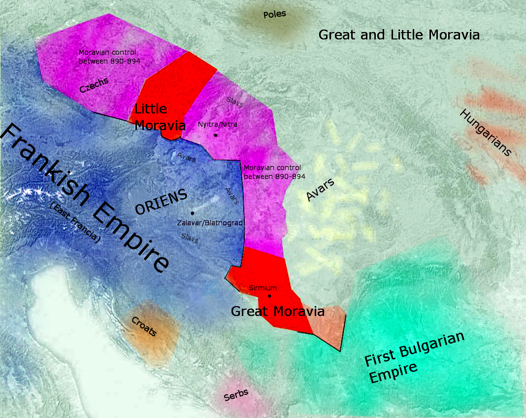
English: Carpathian Basin before the Hungarian conquest. (According to Peter Nagy Puspoki's theory) |
| Source | Own work |
| Author | Fakirbakir |
Source is a public domain (map) http://commons.wikimedia.org/wiki/File:Europe_satellite_image_location_map.jpg Items derive from http://www.tankonyvtar.hu/site/img/historia/1986_86-01_08_Puspoki1_original.jpg
Peter Püspöki Nagy, a Slovak historian who proposed in his study, initially published in 1978 and later in 1982, existence of two Moravias based on the sources of De administrando imperio(DAI) and Bavarian Geographer. The latter source distinguishes between Marharii, identified by Nagy as neighbors of Bohemians, and Marehanii, who bordered on the Bulgars farther to the southeast.
Licensing edit
| I, the copyright holder of this work, release this work into the public domain. This applies worldwide. In some countries this may not be legally possible; if so: I grant anyone the right to use this work for any purpose, without any conditions, unless such conditions are required by law. |
File history
Click on a date/time to view the file as it appeared at that time.
| Date/Time | Thumbnail | Dimensions | User | Comment | |
|---|---|---|---|---|---|
| current | 09:57, 4 October 2010 | | 1,068 × 848 (960 KB) | Fakirbakir (talk | contribs) | minor border repairing |
| 09:01, 4 October 2010 |  | 1,068 × 848 (949 KB) | Fakirbakir (talk | contribs) | Minor repairs, Avars-Slavs | |
| 08:53, 3 October 2010 |  | 1,068 × 848 (924 KB) | Fakirbakir (talk | contribs) | Poles, Croats etc... | |
| 10:07, 2 October 2010 |  | 1,068 × 848 (258 KB) | Fakirbakir (talk | contribs) | {{Information |Description={{en|1=Carpathian Basin before the Hungarian conquest. (According to Peter Nagy Puspoki's theory)}} |Source={{own}} |Author=Fakirbakir |Date= |Permission= |other_versions= }} Source is a public domain (map) h |
You cannot overwrite this file.
File usage on Commons
The following 2 pages use this file:
File usage on other wikis
The following other wikis use this file:
- Usage on de.wikipedia.org
- Usage on en.wikipedia.org
- Usage on hr.wikipedia.org
- Usage on hu.wikipedia.org
- Usage on id.wikipedia.org
- Usage on it.wikipedia.org
- Usage on ru.wikipedia.org
- Usage on sh.wikipedia.org
- Usage on sk.wikipedia.org
- Usage on sr.wikipedia.org