File:Great Salt Lake (MODIS 2020-08-11).jpg

Original file (1,888 × 1,596 pixels, file size: 399 KB, MIME type: image/jpeg)
Captions
Captions
Summary edit
.jpg&action=edit§ion=1)
| Description |
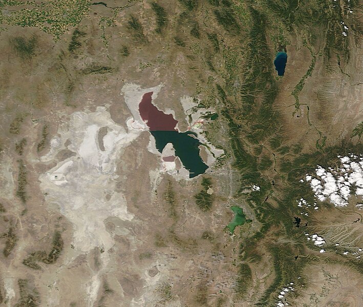
English: The Great Salt Lake claims the title of the largest water body in the United States after the Great Lakes. Once just a small part of prehistoric Lake Bonneville which spread over parts of Utah, Idaho, and Nevada, today’s lake measures about 75 miles (120 km) long and 35 mi (56 km) wide.
The Great Salt Lake is a terminal basin, which means the water that pours into the lake from rivers and streams has no outlet other than evaporation. With a large surface area relative to depth, evaporation is constant, leading to high salinity in the lake. The salinity, however, is not uniform. The north arm of the lake claims about twice the salinity of the rest of the lake due to impoundment of water by a railroad causeway that crosses the lake from east to west. The restriction of water flow by the causeway makes two very different ecosystems, which leads to two different colors that are easily seen from space. North of the causeway, the red algae Dunaliella salina and the bacterial species Halobacterium produce a pronounced reddish cast to the water, whereas south of the causeway, the water color is dominated by green algae such as Dunaliella viridis. Although the briny waters are too salty to support fish, brine shrimp and brine flies flourish in the ecosystem. The lake and surrounding wetlands are also a major stopover point for migratory birds including avocets, stilts, and plovers. On August 2, 2020, the Moderate Resolution Imaging Spectroradiometer (MODIS) on board NASA’s Terra satellite acquired a true-color image of the Great Salt Lake. The abrupt change in color between the north and south can easily be appreciated from this image. A white wash to the tan sands surrounding the Great Salt Lake mark mineral crusts left behind by evaporation. These also can be seen to the west and southwest of the lake, marking the remnants of Lake Bonneville. |
||
| Date | Taken on 2 August 2020 | ||
| Source |
|
||
| Author | MODIS Land Rapid Response Team, NASA GSFC |
| This media is a product of the Terra mission Credit and attribution belongs to the mission team, if not already specified in the "author" row |
Licensing edit
.jpg&action=edit§ion=2)
| This file is in the public domain in the United States because it was solely created by NASA. NASA copyright policy states that "NASA material is not protected by copyright unless noted". (See Template:PD-USGov, NASA copyright policy page or JPL Image Use Policy.) | ||
 |
Warnings:
|
File history
Click on a date/time to view the file as it appeared at that time.
| Date/Time | Thumbnail | Dimensions | User | Comment | |
|---|---|---|---|---|---|
| current | 02:53, 17 February 2024 | | 1,888 × 1,596 (399 KB) | OptimusPrimeBot (talk | contribs) | #Spacemedia - Upload of http://modis.gsfc.nasa.gov/gallery/images/image08112020_250m.jpg via Commons:Spacemedia |
You cannot overwrite this file.
File usage on Commons
There are no pages that use this file.
.jpg&oldid=852747407)