File:Greco trail map 2012.png

Size of this preview: 774 × 600 pixels. Other resolutions: 310 × 240 pixels | 619 × 480 pixels | 1,000 × 775 pixels.
Original file (1,000 × 775 pixels, file size: 674 KB, MIME type: image/png)
Captions
Captions
Add a one-line explanation of what this file represents
Summary edit
| Description |
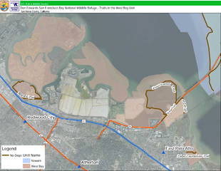
English: Trails near Greco Island and Bair Island in the Don Edwards San Francisco Bay National Wildlife Refuge |
| Date | |
| Source | https://www.fws.gov/uploadedFiles/Appendices_Vol%202of2.pdf |
| Author | U.S. Fish & Wildlife Service |
Licensing edit
This image or recording is the work of a U.S. Fish and Wildlife Service employee, taken or made as part of that person's official duties. As a work of the U.S. federal government, the image is in the public domain. For more information, see the Fish and Wildlife Service copyright policy.
|
 |
File history
Click on a date/time to view the file as it appeared at that time.
| Date/Time | Thumbnail | Dimensions | User | Comment | |
|---|---|---|---|---|---|
| current | 21:53, 4 January 2017 | | 1,000 × 775 (674 KB) | Jeanjung212 (talk | contribs) | User created page with UploadWizard |
You cannot overwrite this file.
File usage on Commons
The following page uses this file:
File usage on other wikis
The following other wikis use this file:
- Usage on en.wikipedia.org
- Usage on www.wikidata.org