File:Greece (MODIS 2018-04-11).jpg

Original file (2,785 × 2,090 pixels, file size: 572 KB, MIME type: image/jpeg)
Captions
Captions
Summary
edit.jpg&action=edit§ion=1)
| Description |
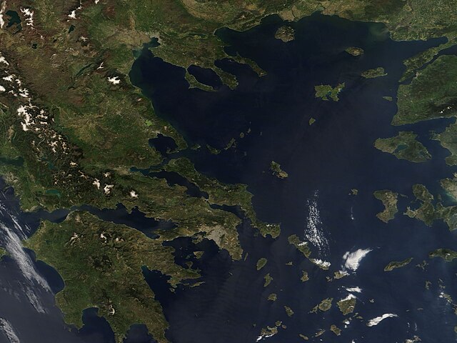
English: On April 9, 2018, the Moderate Resolution Imaging Spectroradiometer (MODIS) aboard NASA’s Terra satellite acquired a true-color image of Greece.
Greece forms the southern tip of the Balkan Peninsula. The mountainous terrain of the country extends from well inland and tumbles into the sea, extending into scattered islands that sit primarily in the Aegean Sea (in the east). In this image, the Pindus Mountains in western Greece can be seen capped with snow while the native dark green vegetation – primarily forest – grows along the mountain ranges. Lighter green areas are mostly agricultural areas. Athens, the capital and the largest city in Greece – and one of the world’s oldest cities – makes its mark on the landscape as a large grayish smudge just south of center in this image. The skies over southern Greece appear to wear a light tan haze. Most likely this is the leading edge of a wave of dust coming from the south – from either the Sahara Desert or Libya. Sand and dust storms are common in those regions, especially in the spring, and dust often travels northward through the atmosphere to reach Greece and beyond. According to local news media, the Athens Observatory reported that one of the largest transfers of Saharan dust to Greece ever recorded took place on March 22 of this year. The PM10 (particulate matter of 10 micrometers in size or less) exceeded 500 micrograms per cubic meter. Also known as “inhalable particles”, the 24-hour PM10 level considered safe by the US Environmental Protection Agency (EPA) is 150 micrograms per cubic meter while in California the 24-hour safe level is 50 microgram per cubic meter. Another wave of dust was forecast to sweep northward from April 9 – 12. It is not expected to be as severe as the late March storm. |
||
| Date | Taken on 9 April 2018 | ||
| Source |
|
||
| Author | Jeff Schmaltz, MODIS Land Rapid Response Team, NASA GSFC |
| This media is a product of the Terra mission Credit and attribution belongs to the mission team, if not already specified in the "author" row |
Licensing
edit.jpg&action=edit§ion=2)
| This file is in the public domain in the United States because it was solely created by NASA. NASA copyright policy states that "NASA material is not protected by copyright unless noted". (See Template:PD-USGov, NASA copyright policy page or JPL Image Use Policy.) | ||
 |
Warnings:
|
File history
Click on a date/time to view the file as it appeared at that time.
| Date/Time | Thumbnail | Dimensions | User | Comment | |
|---|---|---|---|---|---|
| current | 01:49, 17 February 2024 | | 2,785 × 2,090 (572 KB) | OptimusPrimeBot (talk | contribs) | #Spacemedia - Upload of http://modis.gsfc.nasa.gov/gallery/images/image04112018_250m.jpg via Commons:Spacemedia |
You cannot overwrite this file.
File usage on Commons
There are no pages that use this file.
.jpg&oldid=909380373)