File:Gros Ventre land cessions (3 of 4) - after 1888.png

Size of this preview: 800 × 423 pixels. Other resolutions: 320 × 169 pixels | 640 × 339 pixels | 1,024 × 542 pixels | 1,280 × 677 pixels | 2,215 × 1,172 pixels.
Original file (2,215 × 1,172 pixels, file size: 4.79 MB, MIME type: image/png)
Captions
Captions
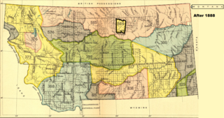
The Fort Belknap Reservation (Gros Ventre and Assiniboine), 1888
Summary
edit_-_after_1888.png&action=edit§ion=1)
| Description |
Dansk: Kort med gros ventre- og assiniboine-indianernes fællesreservat i 1888
English: The map shows the Fort Belknap Reservation shared by the Gros Ventres and the Assiniboines, May 1, 1888 |
| Date | |
| Source | Royce, Charles C.: INDIAN LAND CESSIONS IN THE UNITED STATES. EIGHTEENTH ANNUAL REPORT. BUREAU OF AMERICAN ETHNOLOGY. THE SMITHSONIAN INSTITUTION. 1896-'97. PART 2. WASHINGTON. GOVERNMENT PRINTING OFFICE. 1899 |
| Author | Compiled by Charles C. Royce. (Map adapted to text about the Gros Ventre) |
Licensing
edit_-_after_1888.png&action=edit§ion=2)
| This work is from the Library of Congress. According to the library, there are no known copyright restrictions on the use of this work. |  |

|
This is a file uploaded through the Danish Wikipedia, which has not been reviewed on Commons:
|
File history
Click on a date/time to view the file as it appeared at that time.
| Date/Time | Thumbnail | Dimensions | User | Comment | |
|---|---|---|---|---|---|
| current | 08:41, 3 April 2022 | | 2,215 × 1,172 (4.79 MB) | Indianertosset (talk | contribs) | Uploaded a work by Compiled by Charles C. Royce. (Map adapted to text about the Gros Ventre) from Royce, Charles C.: INDIAN LAND CESSIONS IN THE UNITED STATES. EIGHTEENTH ANNUAL REPORT. BUREAU OF AMERICAN ETHNOLOGY. THE SMITHSONIAN INSTITUTION. 1896-'97. PART 2. WASHINGTON. GOVERNMENT PRINTING OFFICE. 1899 with UploadWizard |
You cannot overwrite this file.
File usage on Commons
There are no pages that use this file.
File usage on other wikis
The following other wikis use this file:
- Usage on da.wikipedia.org
_-_after_1888.png&oldid=806103670)