File:Grossgliederung Europas-ca.svg

Size of this PNG preview of this SVG file: 575 × 599 pixels. Other resolutions: 230 × 240 pixels | 461 × 480 pixels | 737 × 768 pixels | 983 × 1,024 pixels | 1,966 × 2,048 pixels | 911 × 949 pixels.
Original file (SVG file, nominally 911 × 949 pixels, file size: 1.18 MB)
Captions
Captions
Add a one-line explanation of what this file represents
Summary edit
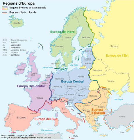
| Description |
Català: Regions europees proposades per Ständiger Ausschuss für geographische Namen (StAGN) |
| Date | |
| Source |
self-made, translation of a map from NordNordWest and an idea from Lencer using
|
| Author | NordNordWest, translated by Jordirooca |
| Other versions |
[]
|


Licensing edit
This file is licensed under the Creative Commons Attribution-Share Alike 3.0 Unported license.
- You are free:
- to share – to copy, distribute and transmit the work
- to remix – to adapt the work
- Under the following conditions:
- attribution – You must give appropriate credit, provide a link to the license, and indicate if changes were made. You may do so in any reasonable manner, but not in any way that suggests the licensor endorses you or your use.
- share alike – If you remix, transform, or build upon the material, you must distribute your contributions under the same or compatible license as the original.
File history
Click on a date/time to view the file as it appeared at that time.
| Date/Time | Thumbnail | Dimensions | User | Comment | |
|---|---|---|---|---|---|
| current | 07:39, 28 April 2022 | | 911 × 949 (1.18 MB) | Jordirooca (talk | contribs) | Uploaded a work by NordNordWest, translated by Jordirooca from self-made, translation of a map from NordNordWest and an idea from Lencer using * P. Jordan: „Großgliederung Europas nach kulturräumlichen Kriterien“, Europa Regional 13 (2005), Heft 4, Leibniz-Institut für Länderkunde, Leipzig * Karte Europa Grünes Band.png with UploadWizard |
You cannot overwrite this file.
File usage on Commons
The following 19 pages use this file:
- File:Grossgliederung Europas-an.svg
- File:Grossgliederung Europas-ar.svg
- File:Grossgliederung Europas-ca.svg
- File:Grossgliederung Europas-ca (1).svg (file redirect)
- File:Grossgliederung Europas-en.svg
- File:Grossgliederung Europas-es.svg
- File:Grossgliederung Europas-fr.png
- File:Grossgliederung Europas-fr.svg
- File:Grossgliederung Europas-hr.svg
- File:Grossgliederung Europas-hy.png
- File:Grossgliederung Europas-jv.svg
- File:Grossgliederung Europas-lb.svg
- File:Grossgliederung Europas-mk.svg
- File:Grossgliederung Europas-ru.svg
- File:Grossgliederung Europas-ua.svg
- File:Grossgliederung Europas-zh.svg
- File:Grossgliederung Europas.png
- File:Grossgliederung Europas.svg
- Template:Other versions/Grossgliederung Europas
.svg&redirect=no)
File usage on other wikis
The following other wikis use this file:
- Usage on ca.wikipedia.org